Draw on the Agas Map
¶Make Your Own Map
The Agas Map interface can be used to create a downloadable image of the map with
your own line, shape, or point marked thereon. This feature allows you to add a custom
map to a slidedeck for classroom or presentation purposes. You can also reproduce
your image in a publication (with credit to MoEML but without permission). At this
time, it isn’t possible to create a map with more than one shape, line, or point.
Locations are plotted on the map in three
forms:
-
Polygons: closed shapes
-
MultiLineStrings: lines with multiple points
-
Points: single points
Each of these forms serve a different purpose, depending on the type of location you
are encoding; each of these shapes and their purposes are discussed in more detail
below.
¶Creating a Polygon
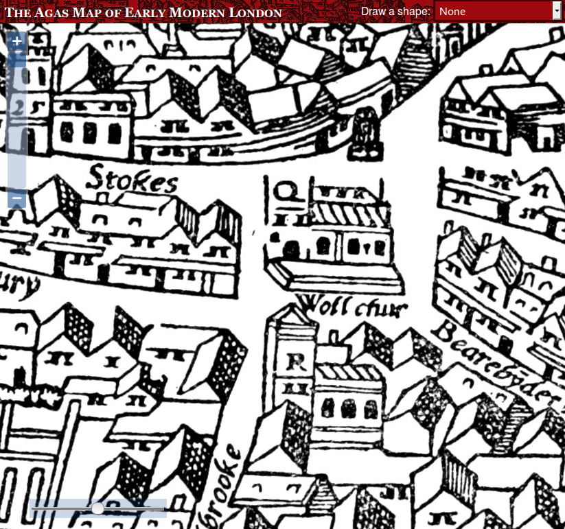
To create a polygon shape, first zoom right into the map so that the shape you want
to
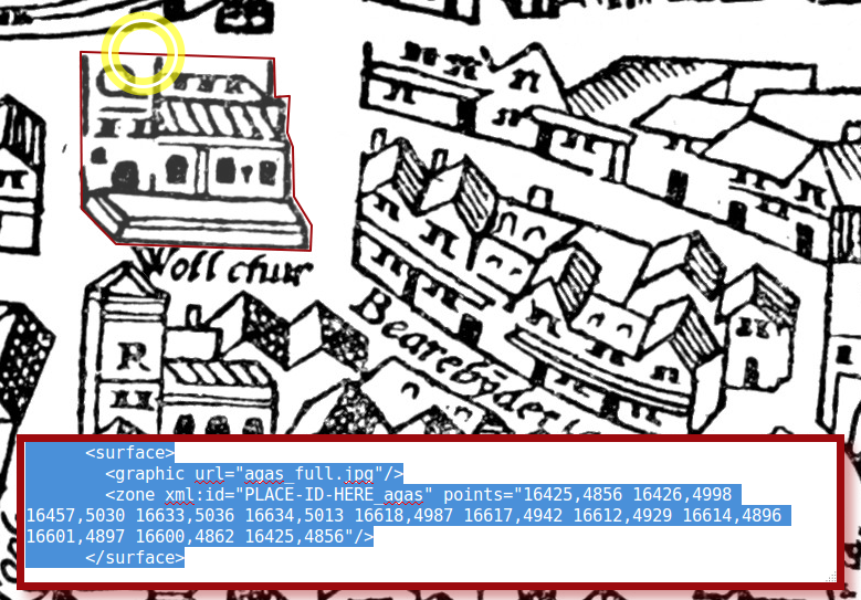
outline is taking up most of the window. In this example, we’re going to outline St. Mary Woolchurch:
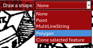
Then choose Polygon from the Draw a shape drop-down list:
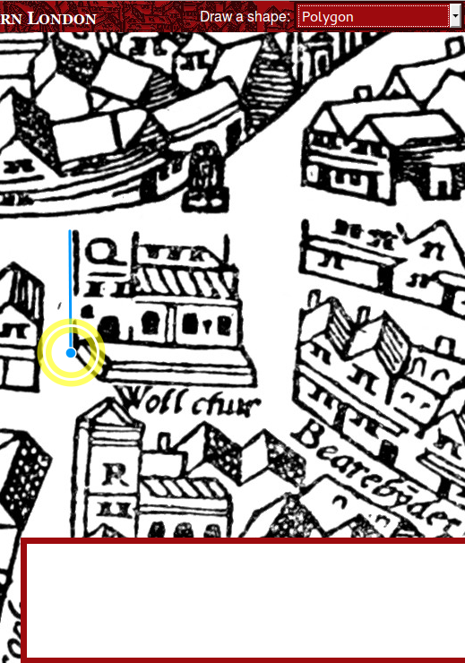
A red box appears at the bottom of the screen, with some XML code for encoding purposes
that you don’t need to worry about when drawing on the map. You’ll notice that the
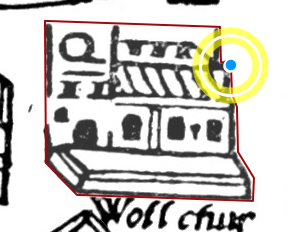
cursor turns to a blue point. Now you can click on one of the corners of the object
to add a point. Move your mouse to the next corner, and click there to add the next
point:
Keep adding points until you have outlined the whole object:
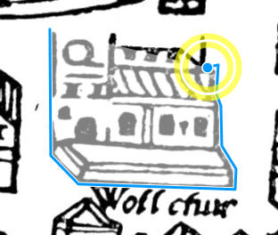
Click back on the original starting point to complete the shape.
Note that it’s good practice to observe the right-hand rules (going from right to
left).
Once the shape is completed, the colour of the outlining line will change to show
you that it is complete.
What if your shape is not perfect first time around? You can easily edit it after
it’s completed. To do so, place your mouse over one of the existing points, click
and move it to change the shape of your polygon. You may find that you need to change
the polygon at a spot with no points yet; in this case, simply click on that spot
and move your cursor to chenge the shape as needed.
If you need to delete one of the nodes in your shape, press the Shift key and click
on it. This will result in a straight line in the place of the previous point.
It is best to have the map zoomed to its maximum size when you create the shape, because
you’ll be more accurate. If you’re outlining a large area, this may mean that the
shape does not completely fit on the screen. Don’t worry about this; even while you’re
in the middle of drawing the shape, you can still click and hold (hold down the mouse
button), drag the map around, and release without adding a new point in your shape.
It’s only when you click and release immediately that a new point is added.
¶Creating MultiLineStrings
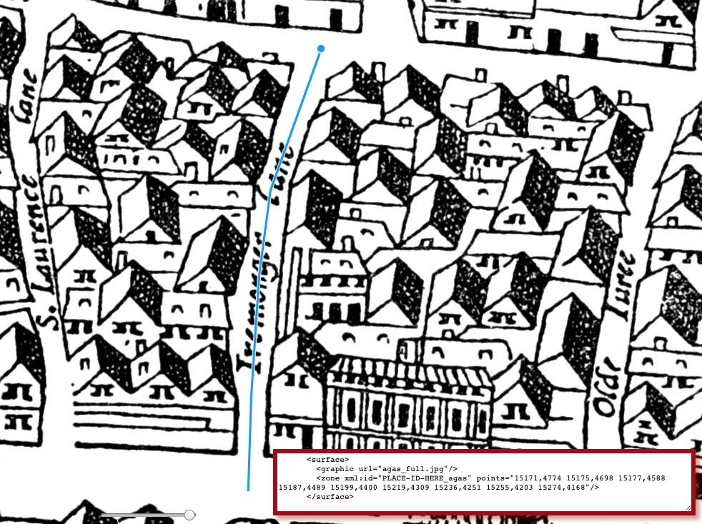
While we usually draw buildings as shapes, streets are drawn
as MultiLineStrings (in other words, a series of connected lines). The process is
exactly the same as for Polygons, except that to finish the shape, you just double-click
on the last point. When tracing a street, start the line in the middle of the junction
where the street starts, and end in the middle of the junction where it ends. Keep
the line in the middle of the street.
¶Creating Points
Some locations cannot be precisely outlined, perhaps because
although we know approximately where they were, they do not
actually appear on the map. You can use a Point for this.
Creating a Point is the simplest process of all: select Point from the drop-down list, then click on the location.
¶Bookmarking Shapes
Just as you can bookmark locations or sets of locations,
you can also bookmark a shape you have created. This can be handy if you’re emailing
someone and would like to refer
to a specific location on the map, if you would like to suggest a particular location
for inclusion, or if you would like to share a custom shape that does not belong in
the database.1 To do this, simply create the
shape as you normally would, and then when you’ve finished, press the Bookmark button. A long,
inscrutable URL will be created and a popup alert will tell you that it is about to
redirect you to the bookmarked URL.
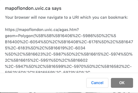
Press OK and the page will redirect you to the bookmark URL. Once the page has reloaded,
you can copy and paste the entire URL in the address bar. If you paste this URL into
a browser, the map will recreate the shape and zoom to it.
¶Downloading an Image
You may also want to download an image of the shape you created (in .png format).
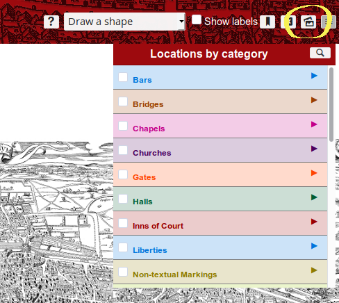
To do so, hover your curser to the top banner of the page, and click on the images
icon (shown below). Note that when you hover over the appropriate icon, the pop-up
should say:
Save this state of the map as a static image.Once you click, the image will automatically be downloaded into your default download folder.
Notes
- See, for instance, the footnote in Silver Street, which shows the house that Shakespeare may have lived in during his stay on Silver Street. (MDH)↑
Cite this page
MLA citation
Draw on the Agas Map.The Map of Early Modern London, Edition 7.0, edited by , U of Victoria, 05 May 2022, mapoflondon.uvic.ca/edition/7.0/draw_on_agas.htm.
Chicago citation
Draw on the Agas Map.The Map of Early Modern London, Edition 7.0. Ed. . Victoria: University of Victoria. Accessed May 05, 2022. mapoflondon.uvic.ca/edition/7.0/draw_on_agas.htm.
APA citation
2022. Draw on the Agas Map. In (Ed), The Map of Early Modern London (Edition 7.0). Victoria: University of Victoria. Retrieved from https://mapoflondon.uvic.ca/editions/7.0/draw_on_agas.htm.
RIS file (for RefMan, RefWorks, EndNote etc.)
Provider: University of Victoria
Database: The Map of Early Modern London
Content: text/plain; charset="utf-8"

TY  - ELEC
A1  - Holmes, Martin
ED  - Jenstad, Janelle
T1  - Draw on the Agas Map
T2  - The Map of Early Modern London
ET  - 7.0
PY  - 2022
DA  - 2022/05/05
CY  - Victoria
PB  - University of Victoria
LA  - English
UR  - https://mapoflondon.uvic.ca/edition/7.0/draw_on_agas.htm
UR  - https://mapoflondon.uvic.ca/edition/7.0/xml/standalone/draw_on_agas.xml
ER  -
TEI citation
<bibl type="mla"><author><name ref="#HOLM3"><surname>Holmes</surname>, <forename>Martin</forename>
<forename>D.</forename></name></author> <title level="a">Draw on the Agas Map</title>.
<title level="m">The Map of Early Modern London</title>, Edition <edition>7.0</edition>,
edited by <editor><name ref="#JENS1"><forename>Janelle</forename> <surname>Jenstad</surname></name></editor>,
<publisher>U of Victoria</publisher>, <date when="2022-05-05">05 May 2022</date>,
<ref target="https://mapoflondon.uvic.ca/edition/7.0/draw_on_agas.htm">mapoflondon.uvic.ca/edition/7.0/draw_on_agas.htm</ref>.</bibl>
Personography
-
Tracey El Hajj
TEH
Junior Programmer 2018-2020. Research Associate 2020-2021. Tracey received her PhD from the Department of English at the University of Victoria in the field of Science and Technology Studies. Her research focuses on the algorhythmics of networked communications. She was a 2019-20 President’s Fellow in Research-Enriched Teaching at UVic, where she taught an advanced course onArtificial Intelligence and Everyday Life.
Tracey was also a member of the Linked Early Modern Drama Online team, between 2019 and 2021. Between 2020 and 2021, she was a fellow in residence at the Praxis Studio for Comparative Media Studies, where she investigated the relationships between artificial intelligence, creativity, health, and justice. As of July 2021, Tracey has moved into the alt-ac world for a term position, while also teaching in the English Department at the University of Victoria.Roles played in the project
-
Author
-
CSS Editor
-
Editor
-
Geo-Coordinate Researcher
-
Junior Programmer
Contributions by this author
Tracey El Hajj is a member of the following organizations and/or groups:
Tracey El Hajj is mentioned in the following documents:
-
-
Joey Takeda
JT
Programmer, 2018-present. Junior Programmer, 2015-2017. Research Assistant, 2014-2017. Joey Takeda was a graduate student at the University of British Columbia in the Department of English (Science and Technology research stream). He completed his BA honours in English (with a minor in Women’s Studies) at the University of Victoria in 2016. His primary research interests included diasporic and indigenous Canadian and American literature, critical theory, cultural studies, and the digital humanities.Roles played in the project
-
Abstract Author
-
Author
-
CSS Editor
-
Compiler
-
Conceptor
-
Copy Editor
-
Editor
-
Encoder
-
Geo-Coordinate Researcher
-
Junior Programmer
-
Markup Editor
-
Post-Conversion Editor
-
Programmer
-
Proofreader
-
Researcher
-
Toponymist
-
Transcriber
-
Transcription Proofreader
Contributions by this author
Joey Takeda is a member of the following organizations and/or groups:
Joey Takeda is mentioned in the following documents:
Joey Takeda authored or edited the following items in MoEML’s bibliography:
-
Jenstad, Janelle and Joseph Takeda.
Making the RA Matter: Pedagogy, Interface, and Practices.
Making Things and Drawing Boundaries: Experiments in the Digital Humanities. Ed. Jentery Sayers. Minnesota: University of Minnesota Press, 2018. Print.
-
-
Janelle Jenstad
JJ
Janelle Jenstad is Associate Professor of English at the University of Victoria, Director of The Map of Early Modern London, and PI of Linked Early Modern Drama Online. She has taught at Queen’s University, the Summer Academy at the Stratford Festival, the University of Windsor, and the University of Victoria. With Jennifer Roberts-Smith and Mark Kaethler, she co-edited Shakespeare’s Language in Digital Media (Routledge). She has prepared a documentary edition of John Stow’s A Survey of London (1598 text) for MoEML and is currently editing The Merchant of Venice (with Stephen Wittek) and Heywood’s 2 If You Know Not Me You Know Nobody for DRE. Her articles have appeared in Digital Humanities Quarterly, Renaissance and Reformation,Journal of Medieval and Early Modern Studies, Early Modern Literary Studies, Elizabethan Theatre, Shakespeare Bulletin: A Journal of Performance Criticism, and The Silver Society Journal. Her book chapters have appeared (or will appear) in Institutional Culture in Early Modern Society (Brill, 2004), Shakespeare, Language and the Stage, The Fifth Wall: Approaches to Shakespeare from Criticism, Performance and Theatre Studies (Arden/Thomson Learning, 2005), Approaches to Teaching Othello (Modern Language Association, 2005), Performing Maternity in Early Modern England (Ashgate, 2007), New Directions in the Geohumanities: Art, Text, and History at the Edge of Place (Routledge, 2011), Early Modern Studies and the Digital Turn (Iter, 2016), Teaching Early Modern English Literature from the Archives (MLA, 2015), Placing Names: Enriching and Integrating Gazetteers (Indiana, 2016), Making Things and Drawing Boundaries (Minnesota, 2017), and Rethinking Shakespeare’s Source Study: Audiences, Authors, and Digital Technologies (Routledge, 2018).Roles played in the project
-
Abstract Author
-
Author
-
Author (Preface)
-
Author of Preface
-
Compiler
-
Conceptor
-
Copy Editor
-
Course Instructor
-
Course Supervisor
-
Data Manager
-
Editor
-
Encoder
-
Geo-Coordinate Researcher
-
Markup Editor
-
Peer Reviewer
-
Project Director
-
Proofreader
-
Researcher
-
Toponymist
-
Transcriber
-
Transcription Proofreader
-
Vetter
Contributions by this author
Janelle Jenstad is a member of the following organizations and/or groups:
Janelle Jenstad is mentioned in the following documents:
Janelle Jenstad authored or edited the following items in MoEML’s bibliography:
-
Jenstad, Janelle and Joseph Takeda.
Making the RA Matter: Pedagogy, Interface, and Practices.
Making Things and Drawing Boundaries: Experiments in the Digital Humanities. Ed. Jentery Sayers. Minnesota: University of Minnesota Press, 2018. Print. -
Jenstad, Janelle.
Building a Gazetteer for Early Modern London, 1550-1650.
Placing Names. Ed. Merrick Lex Berman, Ruth Mostern, and Humphrey Southall. Bloomington and Indianapolis: Indiana UP, 2016. 129-145. -
Jenstad, Janelle.
The Burse and the Merchant’s Purse: Coin, Credit, and the Nation in Heywood’s 2 If You Know Not Me You Know Nobody.
The Elizabethan Theatre XV. Ed. C.E. McGee and A.L. Magnusson. Toronto: P.D. Meany, 2002. 181–202. Print. -
Jenstad, Janelle.
Early Modern Literary Studies 8.2 (2002): 5.1–26..The City Cannot Hold You
: Social Conversion in the Goldsmith’s Shop. -
Jenstad, Janelle.
The Silver Society Journal 10 (1998): 40–43.The Gouldesmythes Storehowse
: Early Evidence for Specialisation. -
Jenstad, Janelle.
Lying-in Like a Countess: The Lisle Letters, the Cecil Family, and A Chaste Maid in Cheapside.
Journal of Medieval and Early Modern Studies 34 (2004): 373–403. doi:10.1215/10829636–34–2–373. -
Jenstad, Janelle.
Public Glory, Private Gilt: The Goldsmiths’ Company and the Spectacle of Punishment.
Institutional Culture in Early Modern Society. Ed. Anne Goldgar and Robert Frost. Leiden: Brill, 2004. 191–217. Print. -
Jenstad, Janelle.
Smock Secrets: Birth and Women’s Mysteries on the Early Modern Stage.
Performing Maternity in Early Modern England. Ed. Katherine Moncrief and Kathryn McPherson. Aldershot: Ashgate, 2007. 87–99. Print. -
Jenstad, Janelle.
Using Early Modern Maps in Literary Studies: Views and Caveats from London.
GeoHumanities: Art, History, Text at the Edge of Place. Ed. Michael Dear, James Ketchum, Sarah Luria, and Doug Richardson. London: Routledge, 2011. Print. -
Jenstad, Janelle.
Versioning John Stow’s A Survey of London, or, What’s New in 1618 and 1633?.
Janelle Jenstad Blog. https://janellejenstad.com/2013/03/20/versioning-john-stows-a-survey-of-london-or-whats-new-in-1618-and-1633/. -
Shakespeare, William. The Merchant of Venice. Ed. Janelle Jenstad. Internet Shakespeare Editions. U of Victoria. http://internetshakespeare.uvic.ca/Library/Texts/MV/.
-
Stow, John. A SVRVAY OF LONDON. Contayning the Originall, Antiquity, Increase, Moderne estate, and description of that Citie, written in the yeare 1598. by Iohn Stow Citizen of London. Also an Apologie (or defence) against the opinion of some men, concerning that Citie, the greatnesse thereof. With an Appendix, containing in Latine, Libellum de situ & nobilitate Londini: written by William Fitzstephen, in the raigne of Henry the second. Ed. Janelle Jenstad and the MoEML Team. MoEML. Transcribed.
-
-
Martin D. Holmes
MDH
Programmer at the University of Victoria Humanities Computing and Media Centre (HCMC). Martin ported the MOL project from its original PHP incarnation to a pure eXist database implementation in the fall of 2011. Since then, he has been lead programmer on the project and has also been responsible for maintaining the project schemas. He was a co-applicant on MoEML’s 2012 SSHRC Insight Grant.Roles played in the project
-
Abstract Author
-
Author
-
Conceptor
-
Editor
-
Encoder
-
Geo-Coordinate Researcher
-
Markup Editor
-
Post-Conversion Editor
-
Programmer
-
Proofreader
-
Researcher
Contributions by this author
Martin D. Holmes is a member of the following organizations and/or groups:
Martin D. Holmes is mentioned in the following documents:
-
Locations
-
St. Mary Woolchurch is mentioned in the following documents:
-
Silver Street
Silver Street was a small but historically significant street that ran east-west, emerging out of Noble Street in the west and merging into Addle Street in the east. Monkwell Street (labelledMuggle St.
on the Agas map) lay to the north of Silver Street and seems to have marked its westernmost point, and Little Wood Street, also to the north, marked its easternmost point. Silver Street ran through Cripplegate Ward and Farringdon Within Ward. It is labelled asSyluer Str.
on the Agas map and is drawn correctly. Perhaps the most noteworthy historical fact about Silver Street is that it was the location of one of the houses in which William Shakespeare dwelled during his time in London.Silver Street is mentioned in the following documents:


