Arundel House (c. 1221-1682) was located on the Thames between Milford Lane and Strand Lane. It was to the east of Somerset House, to the south of St. Clement Danes, and adjacent to the Roman Baths at Strand Lane. Walter Thornbury locates it Between Milford Lane and Strand Lane—a narrow and rather winding thoroughfare leading to the Embankment a few yards to
the east of Somerset House—the entire space, about three hundred yards in length and the same in breadth (Thornbury 63-84). The plot of land was 40 ½ ells in width,1 21 ¾ ells at one end, and at the other, sloping towards the Thames, 25 ¼ ells (A Descriptive Catalogue 194, A. 1665), making the property footprint approximately 13,000 square feet. James Howell describes
its location thus in 1657:
Then was the Bishop of Baths Inne, or City-House, builded by the Lord Thomas Seamer, Admiral of England: which House, came afterwards to be possessed by the Earl of Arundel, & so it beares the name of Arundel-house: neer there adjoyning, there was once a Parish-Church, called the Nativity of our
Lady, or the Innocents of the Strand, with a fair Cœmitery, or Church-yard, wherein
there was a Brother-hood kept, called Saint Vrsula of the Strand.2 (Howell 349)
Plan of Arundel and Essex Houses (From an original Etching by Hollar, published in
Ogilby and Morgan’s Twenty-Sheet Plan of London). Courtesy of BHO.
A number of early modern maps depict the location of Arundel House. These maps show the physical changes made to the house over the years and offer
insight into its cultural significance, as it becomes more prominently featured over
time. The Wyngaerde map (Part 1 and Part 2), surveyed between 1543 and 1550, features the architecture of the Strand. G.E. Mitton identifies Durham House, Savoy Palace, and Somerset House (Mitton 6) on this map, but Arundel House is not specifically locatable. During the time the Wyngaerade map was made, Thomas Seymour was just beginning to remodel the structures. Arundel House is not labeled in this image because it had not yet become a London landmark.
As the house gained notoriety, cartographers began representing it more carefully. Braun, Hogenberg, and Hoefnagel’s map Londinium Feracissimi Angliae Regni Metropolis, begun in 1560 and completed in the 1570s, depicts Arundel House, labeling it Arundell P. This map outlines the sections of the gardens.
The Civitas Londinum or Agas map, featured here on MoEML, shows the additional wings of Arundel Housevery rudely (Kingsford 249n2).
Ogilby and Morgan’s 1677map shows Arundel House in great detail. The house is carefully labeled. Mitton writes, to the south are the great houses of Essex and Arundel, with their gardens; their
names are preserved in the streets that flow over their sites (Mitton 19). The accuracy with which cartographers represented Arundel House improves in proportion to its notoriety in London.
Morgan’s 1682/3Plan of the Districtmap reveals the demolition of Arundel House, citing the location as ground for Arundel house. Morden and Lea’s 1690Survey of London cites only the Arundell Stairs.
Arundel House (1549-c. 1680-1682), spelled variously as Arundel,Arundell,Arondel, and Arondell, was previously known as Bath Place or Bath Inn (1232-1539), Hampton Place (1539-1545), and Seymour Place (1545-1549).3John Stow retells this etymological history in his Survey of London: Then was the Bishop of Bathes Inne, lately new builded, for a great parte thereof by the Lorde Thomas Seamer Admirall, which came sithence to be possessed by the Earle of Arondell, and thereof called Arundell house (Stow 365). Philemon Holland’s1610 English translation and emendation of William Camden’s 1607 Latin Britannia notes its tenure as Hampton Place: Arondel house before called Hampton place (Camden 428). A 1545 Grant shows its etymological change from Bath Place to Hampton Place to Seymour Place: Sir Thomas Seymour, the Kings servant. Grant, in fee, for 700l., of the chief mansion and chief messuage
called Hampton Place alias Bathe Place in the Parish of St. Clement without the bars of the New Temple, London (Grants in November, 1545 910.77). After 1549, it kept the name Arundel House until it was demolished between 1680 and 1682.
Today, Arundel Street remains in London as a reminder of the house’s former location. A new Arundel House, constructed in the Tudor Revival style in the nineteenth century, currently stands
on the corner of Arundel Street and has housed the International Institute for Strategic Studies since 1997. This building is unrelated to the original medieval and early modern
estate.
In the Medieval period, Bath Inn (later Arundel House) was the largest of the episcopal properties on the Strand, first granted to Eustace de Fauconberg who became bishop of London in 1221. The bishops of Bath and Wells subsequently inherited the property on 23 September 1232, Giving to the churches of Wells and Bath, and succeeding bishops, a place formerly
belonging to Eustace, bishop of London, in the suburbs of London in the street of St. Clement without the Bar, with all the houses and buildings there (Calendar of the Charter Rolls 168-169). It remained an episcopal property for over three hundred years.
Thomas Seymour inherited the property in 1545 and significantly remodeled the house. Historian Charles Lethbridge Kingsford summarizes
the alterations, which blended old and new: what he did was probably to erect the extensive blocks stretching from the southwest
corner of the old house and down to the river, whilst preserving the ancient courtyard
and hall (Kingsford 249).
When Thomas Seymour was executed for treason, Henry Fitzalan, twelfth/nineteenth Earl of Arundel, purchased the newly remodeled house and named
it Arundel House. John Strype relates this change: Then was the Bishop of Baths Inn, (called also Hampton Place) lately new builded (for a great Part thereof) by the Lord Thomas Seimour, Admiral, being parcel of his Possessions. This House of the Bishop of Bath and Wells was assured to the said Admiral Seimour in King Edward the Sixth’s Reign; and is now quite severed from that Bishoprick without Recompence. Which House came
sithence to be possessed by the Earl of Arundel, and thereof called Arundel House (Strype 4.7.105).
Philip Howard, thirteenth/twentieth Earl of Arundel, was convicted of treason in 1585. His wife, Anne, was relegated to tenancy with limited movement throughout the estate.4 In 1589, an extensive survey was performed, revealing a property footprint of over 150,000
square feet. The survey highlighted the structures in need of repair, including a
storehouse, lodging, barn and stables, bakehouse and coalhouse, bowling alley, kitchen
court, and vaulted cellar (Hammerson 212).5 These structures were likely part of the older Bath Inn. The 1589 survey mentions only briefly the newer sections of the house added by Seymour.
When Philip Howard died in the Tower of London in 1595, the Crown took possession of the house. Philip’s son, Thomas Howard, fourteenth/twenty-first Earl of Arundel, used his wife, Lady Alethea Talbot’s, money to purchase the house in 1607 (Calendar of State Papers, James I 390). By buying back the house, Thomas Howard hoped to recoup his family’s damaged reputation. During Thomas Howard’s ownership, the house achieved notoriety in respect to design and decoration, welcoming
artists such as Wenceslas Hollar and Inigo Jones. Thomas Howard died in 1646 while in Italy and the house passed to the care of Parliament. During the English
Civil War, Arundel House was used as a garrison and consequently fell into disrepair.
Henry Howard gained approval for extensive construction on site, as well for the more beautifying the said buildings by bringing them to a more just
symmetry and proportion all along the river, as for enlarging the gardens of the House (Calendar of State Papers, Charles II226). None of these construction projects materialized, despite completed plans from
Christopher Wren. The house was subsequently demolished between 1680 and 1682 and no new structure was erected in its place.
The site was excavated in 1972 by a team of archaeologists.
A number of significant political events are directly connected to Arundel House, including Henry VIII’s divorce from Katherine of Aragon; Princess Elizabeth’s upbringing; and Catholic plots against the monarchy.
In the 1540s, Princess (later Queen) Elizabeth stayed at Arundel House, then known as Seymour Place. Seymour Place provided the site of her alleged affair with Thomas Seymour. Elizabeth’s governess, Mrs. Ashley, reported these interactions: At Seymour Place, when the queen slept there, he did use awhile to come up every morning in his nightgown and slippers; when he found
my lady Elizabeth up, and at her book, then he would look in at the gallery-door, and bid her good
morrow, and so go on his way (Memoirs of the Queens 400). Seymour’s flirtations with Princess Elizabeth, whether or not there was ever an actual affair, created suspicions that he was plotting
to marry her — suspicions that contributed to his downfall; Seymour was eventually executed for treason (Bernard).
The House’s association with secret Catholic affairs continued while it was under
the ownership of Philip Howard, who inherited the property from his grandfather Henry Fitzalan. Although Philip was sent to the Tower of London in 1585, a secret Jesuit press very likely operated out of Arundel House throughout the 1580s. While Philip was imprisoned, his wife, Anne, Countess of Arundel harbored the Jesuit Robert Southwell (later made a Catholic Saint) at her properties. Historian Anne Sweeney offers a
concise overview of this secret press:
It was in part under Philip’s aegis that Southwell’s works were at first printed, under the noses of the State authorities, any emergent
notion of ideological censorship seemingly giving way to feudal precedence even in
the 1580s. Whatever the reason for its continued existence, some sort of printing facility
certainly existed, and Weston, Southwell, and the other Jesuits had access to it. There is a mention of a secret press operating
from one of the Arundel houses in the 1588Marprelate pamphlet. (Sweeney 113)
John Charlewood, a well-known publisher enjoying the monopoly of printing play-bills, who styled himself,
at least until 1585: Printer to the Rt. Hon. The Earl of Arundel (Devlin 143), was the publisher responsible for this secret press. Southwell’s An Epistle of Comfort, a series of letters originally written to offer religious encouragement to Philip in the Tower of London, was printed on this secret press, despite the fact that the text claims to have
been printed in Paris (Devlin 143).
Though the Earl and Countess of Arundel’s association with this press is certain, scholars do not agree where the press was
located. Most contend that the press was actually in Arundel House. This is supported by an informant who claimed, I do now remember myself of another printer that had press and letter in a place called
the Charterhouse in London (in Anno 1587, near about the time of the Scottish Queenes death) intelligence was given unto your
good grace of the same by some of the Stationers in London (qtd. in Ames 1466). Devlin establishes that the Charterhouse referenced here is Howard House, also known as Arundel House (Devlin 143). However, Nancy Pollard Brown argues that the press was located at the family’s
other property in the Spitalfields (Brown 123). In 1588, John Gerard made reference to this secret press, but placed it at Anne’s property at Acton, not Arundel House itself: there too that Father Southwell had his printing press, where his own admirable books were produced (qtd. in Devlin 144). Devlin argues that the press must have been moved from one property to another
in order to escape censorship. Regardless of its exact location, this secret press
was part of a larger movement of clandestine Catholic printing in England (Miola 412).
The site again became embroiled in a conspiracy during the Popish Plot in 1678 when witnesses swore that Titus Oates had been living in one corner of Old Arundel House (A Complete Collection of State Trials 402).7
In the seventeenth century, Arundel House became a significant artistic centre in London. According to Haynes, at its greatest extent the sculpture collection is said to have comprised no less
than thirty-seven statues, one hundred and twenty-eight busts and two hundred and
fifty inscriptions, as well as a large number of sarcophagi, altars and fragments (Haynes 10). The inscriptions were ancient Greek and Latin texts carved into pieces of stone
and marble. In a portrait of Thomas Howard by Mytens, one can see the Arundel Eros and the Arundel Homerus now at the Ashmolean.8Howard’s marbles are depicted in another portrait by an anonymous painter, dated to approximately
1627.9 In this portrait, two rows of life-sized marbles can be seen through the window over
Howard’s shoulder, lining the neatly landscaped gardens and showing how the collection
had spilled out of doors.
Arundel House, from the North by Wenceslas Hollar. Courtesy of Wikimedia Commons.Arundel House, from the South by Wenceslas Hollar. Courtesy of Wikimedia Commons.
Howard brought Bohemian artist Wenceslaus Hollar into his service in 1636.11Hollar’s pair of 1646 images Courtyard of Arundel House Facing North and Courtyard of Arundel House Facing South show an older Tudor timber structure. This is not what we would expect from portraits
of Thomas and Alethea Howard by Daniel Mytens, which depict the house in Palladian style. Haynes claims that by the early 1620s,
Arundel House was rapidly assuming the appearance of an Italian palace (Haynes 4). However, Howarth sees Mytens’ artistic representations as entirely fictitious imaginary views (Howarth and Dethloff). Alice Friedman calls this disconnect between Hollar’s depictions and the impression we get from paintings and visitors’ records startling, noting, we expect arches and pediments and columns, not rambling half-timber structures (Friedman 158). These contradictory reports reveal the way material realities and conceptual impressions
(the Italian ideal vs. the pastoral ideal) did not always align.
Arundel House was a cultural centre for elite guests, including British royalty and foreign ambassadors.
King Charles I visited the art collections in December of 1628 and again in 1634 (Hervey 264, 399). Sir Francis Bacon visited in 1626 and expressed shock at the nude statues (Haynes 7). In 1629, the Dutch delegate Abram Booth visited a number of homes in London, keeping a diary with his travels and impressions, and was especially enamored with
the gardens and marbles at Arundel House (Louw 507).
Tours of Arundel House began during Thomas Howard’s residency and remained popular after he died. For instance, Samuel Pepys visited Arundel House on 30 May 1661, touring the gardens, gallery, and wine cellar:
Back to the Wardrobe with my Lord, and then with Mr. Moore to the Temple, and thence to Greatorex, who took me to Arundell-House, and there showed me some fine flowers in his garden, and all the fine statues in
the gallery, which I formerly had seen, and is a brave sight, and thence to a blind
dark cellar, where we had two bottles of good ale, and so after giving him direction
for my silver side-table, I took boat at Arundell stairs, and put in at Milford. (Pepys 30 May 1661)
Pepys also mentions the Arundel Stairs that led directly to the Thames, making the house easily accessible from the main waterway.
Though undeniably an elite estate, so much of the statuary was placed outside on the
bank of the Thames that the general public knew the collection. The bankside display may seem to violate
the division between public and private spaces, but was not unusual for the period.
Other elite private residences, like Whitehall Palace, also served as cultural centres for the public. In 1651, author Christopher Arnold commented on the way Arundel House blurred these boundaries when he wrote of certain gardens on the Thames, where there are rare Greek and Roman inscriptions, stones, marbles; the reading
of which is actually like viewing Greece and Italy at once within the bounds of Great
Britain (qtd. in Chambers 138n.16).12 Though many of the marbles featured carved Latin and Greek inscriptions that could
be literally read, the concept of literacy can be applied more broadly to the way
Arundel House became a living text for the city of London, connecting London to classical and continental history and culture.
After the Restoration, Henry Howard helped Arundel House become a centre for intellectual life in London. After the Great Fire of 1666, the Royal Society met at Arundel House:
Since by the firing of London, the first place of their meeting has been restor’d to its original use, and made
an Exchange, he has afforded them a retreat in his own house, where they assemble
at this present: By which favour he has added a new honour to the antient Nobility
of his Race: one of his Ancestors had before adorn’d that place with many of the best
Monuments of Antiquity: And now by entertaining these new discoveries under his Roof,
his Family deserves the double praise of having cherish’d both the old, and new Learning;
so that now methinks in Arundel house, there is a perfect representation, what the Real Philosophy ought to be: As there
we behold new Inventions to flourish amongst the Marbles, and Images of the Dead:
so the present Arts, that are now rising, should not aim at the destruction of those
that are past, but be content to thrive in their company. (Sprat 253)
Samuel Pepys also mentions the Royal Society’s new home: Mr. Henry Howard, of Norfolke, hath given our Royal Society all his grandfather’s library: which noble gift they
value at 1000l.; and gives them accommodation to meet in at his house, Arundell House, they being now disturbed at Gresham College (Pepys 7 January 1666/7). Pepys attended a number of Royal Society experiments at Arundel House. He saw an experiment with gunpowder, microscopes, and an ear trumpet that allowed
him to plainly hear the dashing of the oares of the boats in the Thames to Arundell gallery window, and an experiment on a dog’s spine (Pepys 9 January 1666/7, 30 May 1667, 2 April 1668, 16 July 1668).
Even after Arundel House was demolished in 1680 to 1682, it was remembered in descriptions of London. John Strype recorded a brief history of Arundel House in his 1720 update to Stow’s A Survey of London, terminating in the house’s demolition:
Formerly the Bishop of Bath’s Inn: Which in Process of Time came to the Family of the Howards, Dukes of Norfolk, the
late Duke dwelling there. It then was a very large and old built House; with a spacious
Yard for Stablings, towards the Strand, and with a Gate to enclose it, where there
was the Porters Lodge; and as large a Garden towards the Thames. This said House and Grounds was some Years since converted into Streets and Buildings. (Strype 4.7.117)
In his 1716 poem Trivia, or, The Art of Walking the Streets of London,John Gay remembers the legacy of Arundel House as he walks through London:
Even though the house had been demolished, it was still able to influence London culture and the experience of moving through and remembering the city.
A 1972 archaeological excavation of the site found very extensive destruction (Hammerson 214) where Arundel House once stood. The majority of remains discovered in the 1970s dated from the sixteenth and seventeenth centuries. The team found no remains from
the medieval Bath Inn house (Hammerson 214). The team was able to map the foundations of the early modern house and excavated
the original cellar in which Pepys drank ale in 1661 (Hammerson 218). They discovered a collection of stoneware, pottery, dishes, tinware, cooking vessels,
and tiles dating from the early modern period. The team also discovered seven classical
marbles from Thomas Howard’s collection that had been lost (Hammerson 247). The architectural skeleton of early modern London continues to be valuable to archaeologists and historians today.
An ell is a unit of measurement, originally a cubit (although later it referred to
longer units), that is, the approximate length of a man’s forearm from his elbow,
about 18 inches. (SM)↑
This church was torn down in 1549 in order to build Somerset House. (SM)↑
MS Lansdowne 45. f. 197. No. 82. After her husband’s death, Countess Anne Howard was contractually relegated to a set of prescribed rooms, including specific passages
and stairways leading to those rooms. Many of these allowable rooms were part of the
old house, referred to as the great old decayed house called the storehouse. She was given a key in her own custody in order to use the gardens. (EKA)↑
For more on the way various private spaces and homes were used in the Ridolfi plot,
see Orlin 247-261. (EKA)↑
The Popish Plot conspiracy was a completely fabricated plot alledging that the Jesuits
were planning to assassinate Charles II. The conspiracy was invented by Titus Oates,
but was widely believed and created widespread anti-Catholic mania, leading tot he
executions of thirty-five people. Oates was eventually discredited and convicted of
perjury (BAE). (SM)↑
Anonymous. Portrait of the Earl of Arundel. c. 1627. Private Collection, Welbeck Estate. (EKA)↑
Kingsford argues that renovations must have accompanied the growing collection: one may suppose that some changes were necessary to provide an adequate setting for
these splendid collections, and Arundel’s letters in 1618-1619 contain some mention
of works in progress (Kingsford 254). (EKA)↑
For more on Hollar’s work in England, see Howarth. (EKA)↑
Arnold is further discussed in Hunt. Hunt calls these gardens a kind of memory theatre (120). (EKA)↑
References
Citation
Grants in November, 1545. 910.77. Henry VIII: November 1545, 26–30.Letters and
Papers, Foreign and Domestic, Henry VIII. Vol. 20, Part 2. Ed. James
Gairdner and R. H. Brodie. London, 1907. Remediated by British History Online.
A Complete Collection of State Trials and Proceedings for High Treason
and Other Crimes and Misdemeanors from the Earliest Period to the Year 1783.
Vol. 7. Ed. T. B. Howell. London: T.C. Hansard, 1816.
A Descriptive Catalogue of Ancient Deeds in the Public Record Office:
prepared under the superintendence of the deputy keeper of the records. Vol.
1. London, 1890. Remediated by Internet Archive.
Ames, Joseph. Typographical Antiquities: or an
historical account of the origin and progress of printing in Great Britain and
Ireland. Vol. 3. London, 1785–1790.
Remediated by Gale.
Bernard, G.W.Seymour, Thomas, Baron Seymour of Sudeley (b. in or before 1509, d.
1549).Oxford Dictionary of National Biography. Ed.
H.C.G. Matthew, Brian Harrison, Lawrence
Goldman, and David Cannadine. Oxford UP. doi:10.1093/ref:odnb/25181.
Calendar of State Papers Domestic Series, of the reign of Charles
II. Vol. 7. 1676–1677. Ed. Mary Anne Everett Green,
F.H.B. Daniell, and F. Bickley. London: H.M.
Stationery Office, 1860–1939.
Camden, William. Britain,
or A chorographicall description of the most flourishing kingdomes, England, Scotland,
and Ireland, and the ilands adjoyning, out of the depth of antiquitie beautified vvith
mappes of the severall shires of England: vvritten first in Latine by William Camden
Clarenceux K. of A. Translated newly into English by Philémon Holland Doctour in
Physick: finally, revised, amended, and enlarged with sundry additions by the said
author. London, 1637. STC 4510.8.
Campeggio. Henry VIII: August 1529,
1–10.Letters and Papers, Foreign and Domestic, Henry
VIII. Vol. 4. Ed. J.S. Brewer. London, 1867. Remediated by British History Online.
Cecil, William. A
Collection of State Papers Relating to Affairs in the Reign of Queen Elizabeth, from
the year 1571 to 1596. Ed. William Murdin. London: William
Bowyer, 1759.
Chambers, Douglas. John Evelyn and English
Architecture.John Evelyn’s Elysium
Britannicum and European Gardening. Vol. 17. Ed. Therese
O’Malley and Joachim Wolschke-Bulmahn. Washington: Dumbarton
Oaks, 1998. Print.
Friedman, Alice T.John Evelyn and English Architecture.John
Evelyn’s Elysium Brutannicum and European Gardening.
Ed. Therese O’Malley and Joachim Wolschke-Bulmahn.
Vol. 17. Washington: Dumbarton Oaks, 1998. Print.
Hammerson, Michael J.Excavations on the Site of Arundel House in the Strand, W.C.2., in
1972.Transactions of the London & Middlesex
Archaeological Society 26 (1976): 209–251.
Holinshed, Raphael and William Harrison. The first and second volumes of Chronicles comprising 1 The description and historie
of England, 2 The description and historie of Ireland, 3 The description and historie
of Scotland: first collected and published by Raphaell Holinshed, William Harrison,
and others: now newlie augmented and continued (with manifold matters of singular
note and worthie memorie) to the yeare 1586. London, 1587.
STC 13569.
Howarth, David. The Arundel Collection: Collecting and
Patronage in England in the Reigns of Philip III and Philip IV.The Sale of the Century: artistic relations between Spain and Great Britain,
1604–1655. Ed. Jonathan Brown and John Huxtable
Elliott. New Haven: Yale UP, 2002. Print.
Howell, James. Londinopolis, an historicall discourse or perlustration of the city of London, the
imperial chamber, and chief emporium of Great Britain whereunto is added another of
the city of Westminster, with the courts of justice, antiquities, and new buildings
thereunto belonging. London, 1657. Wing H3090.
Kingsford, Charles Lethbridge. Bath Inn or Arundel
House.Archaeologia, or Miscellaneous Tracts relating to
Antiquity 72 (1922): 243–277. doi:10.1017/S0261340900009711.
Parliament. April 1539. 868.13. Letters
and Papers: April 1539, 26–30.Letters and Papers, Foreign
and Domestic, Henry VIII. Vol. 14, Part 1. Eds. James
Gairdner and R. H. Brodie. London, 1894. Remediated by British History Online.
Louw, H.J.Some Royal and Other Great Houses in England: Extracts from the Journal
of Abram Booth.Architectural History 27 (1984): 503–509. doi:10.2307/1568491.
Smythson, John. Arundel
House, Strand, London: survey elevation of a rusticated Italyan garden
gate and part of the house’s front façade. c. 1618. RIBA 29204.
Southwell, Robert, Saint. An epistle of comfort to the reverend priests, & to the honorable, worshipful,
& other of the laye sort restrained in durance for the Catholicke fayth.
Imprinted at Paris [i.e. London: By John Charlewood? In Arundel House, 1587?]
STC (2nd ed.) 22946.
Sprat, Thomas. The
History of the Royal-Society of London, for the improving of Natural
Knowledge. London: T.R. for I. Martyn at the Bell without Temple-bar, and I.
Allestry at the Rose and Crown in Duck-lane, 1667. Wing S5032.
Stow, John. A SVRVAY OF
LONDON. Contayning the Originall, Antiquity, Increase, Moderne estate, and description
of that Citie, written in the yeare 1598. by Iohn Stow Citizen of London. Also an
Apologie (or defence) against the opinion of some men, concerning that Citie, the
greatnesse thereof. With an Appendix, containing in Latine, Libellum de situ
&nobilitate Londini: written by William Fitzstephen, in the raigne of Henry the
second. London: John Windet for John Wolfe, 1598. STC 23341.
Strype, John. A SURVEY of
the CITIES of London and Westminster: CONTAINING the Original, Antiquity, Increase,
Modern Estate and Government of those CITIES. London, 1720. An
Electronic Edition of John Strype’s A Survey of London and
Westminster. Ed. Julia Merritt.
hriOnline. https://www.dhi.ac.uk/strype/transcriptions.shtml.
Wolsey, Thomas. Henry VIII: July 1523, 1–15.Letters and Papers, Foreign and
Domestic, Henry VIII. Vol. 3. Ed. J.S. Brewer. London, 1867. Remediated by British History Online.
Atwood, Emma. Arundel House.The Map of Early Modern London, Edition 7.0, edited by Janelle Jenstad, U of Victoria, 05 May 2022, mapoflondon.uvic.ca/edition/7.0/ARUN1.htm.
Chicago citation
Atwood, Emma. Arundel House.The Map of Early Modern London, Edition 7.0. Ed. Janelle Jenstad. Victoria: University of Victoria. Accessed May 05, 2022. mapoflondon.uvic.ca/edition/7.0/ARUN1.htm.
Provider: University of Victoria
Database: The Map of Early Modern London
Content: text/plain; charset="utf-8"

TY  - ELEC
A1  - Atwood, Emma
ED  - Jenstad, Janelle
T1  - Arundel House
T2  - The Map of Early Modern London
ET  - 7.0
PY  - 2022
DA  - 2022/05/05
CY  - Victoria
PB  - University of Victoria
LA  - English
UR  - https://mapoflondon.uvic.ca/edition/7.0/ARUN1.htm
UR  - https://mapoflondon.uvic.ca/edition/7.0/xml/standalone/ARUN1.xml
ER  -
TEI citation
<bibl type="mla"><author><name ref="#ATWO2"><surname>Atwood</surname>, <forename>Emma</forename></name></author>.
<title level="a">Arundel House</title>. <title level="m">The Map of Early Modern London</title>,
Edition <edition>7.0</edition>, edited by <editor><name ref="#JENS1"><forename>Janelle</forename>
<surname>Jenstad</surname></name></editor>, <publisher>U of Victoria</publisher>,
<date when="2022-05-05">05 May 2022</date>, <ref target="https://mapoflondon.uvic.ca/edition/7.0/ARUN1.htm">mapoflondon.uvic.ca/edition/7.0/ARUN1.htm</ref>.</bibl>
Research Assistant, 2020-2021. Managing Encoder, 2020-2021. Jamie Zabel was an MA
student at the University of Victoria in the Department of English. She completed
her BA in English at the University of British Columbia in 2017. She published a paper
in University College London’s graduate publication Moveable Type (2020) and presented at the University of Victoria’s 2021 Digital Humanities Summer
Institute. During her time at MoEML, she made significant contributions to the 1598
and 1633 editions of Stow’s Survey as proofreader, editor, and encoder, coordinated the encoding of the 1633 edition,
and researched and authored a number of encyclopedia articles and geo-coordinates
to supplement both editions. She also played a key role in managing the correction
process of MoEML’s Gazetteer.
Programmer, 2018-present. Junior Programmer, 2015-2017. Research Assistant, 2014-2017.
Joey Takeda was a graduate student at the University of British Columbia in the Department
of English (Science and Technology research stream). He completed his BA honours in
English
(with a minor in Women’s Studies) at the University of Victoria in 2016. His primary
research interests included diasporic and indigenous Canadian and American literature,
critical theory, cultural studies, and the digital humanities.
Joey Takeda authored or edited the following items in MoEML’s bibliography:
Jenstad, Janelle and Joseph Takeda. Making the RA Matter: Pedagogy, Interface, and Practices.Making Things and Drawing Boundaries: Experiments in the Digital Humanities. Ed. Jentery Sayers. Minnesota: University of Minnesota Press, 2018. Print.
Data Manager, 2015-2016. Research Assistant, 2013-2015. Tye completed his undergraduate
honours degree in English at the University of Victoria in 2015.
Research Assistant, 2012-2014. MoEML Research Affiliate. Sarah Milligan completed
her MA
at the University of Victoria in 2012 on the invalid persona in Elizabeth Barrett
Browning’s
Sonnets from the Portuguese. She has also worked with the Internet Shakespeare
Editions and with Dr.
Alison Chapman on the Victorian Poetry Network, compiling an index of Victorian periodical
poetry.
Director of Pedagogy and Outreach, 2015–2020. Associate Project Director, 2015.
Assistant Project Director, 2013-2014. MoEML Research Fellow, 2013. Kim McLean-Fiander
comes
to The Map of Early Modern London from the Cultures of Knowledge
digital humanities project at the University of
Oxford, where she was the editor of Early Modern Letters Online, an open-access union
catalogue and editorial interface for correspondence from the sixteenth to eighteenth
centuries. She is currently Co-Director of a sister project to EMLO called Women’s Early Modern Letters Online (WEMLO). In the past, she held an internship with the
curator of manuscripts at the Folger Shakespeare
Library, completed a doctorate at Oxford on
paratext and early modern women writers, and worked a number of years for the Bodleian Libraries and as a freelance editor.
She has a passion for rare books and manuscripts as social and material artifacts,
and is
interested in the development of digital resources that will improve access to these
materials while ensuring their ongoing preservation and conservation. An avid traveler,
Kim
has always loved both London and maps, and so is particularly delighted to be able
to bring
her early modern scholarly expertise to bear on the MoEML project.
Janelle Jenstad is Associate Professor of English at the University of Victoria, Director
of The Map of Early Modern London, and PI of Linked Early Modern Drama Online. She has taught at Queen’s University, the Summer
Academy at the Stratford Festival, the University of Windsor, and the University of
Victoria. With Jennifer Roberts-Smith and Mark Kaethler, she co-edited Shakespeare’s Language in Digital Media (Routledge). She has prepared a documentary edition of John Stow’s A
Survey of London (1598 text) for MoEML and is currently editing The Merchant of Venice (with Stephen Wittek) and Heywood’s 2 If
You Know Not Me You Know Nobody for DRE. Her articles have appeared in Digital Humanities Quarterly, Renaissance and
Reformation,Journal of Medieval and Early Modern Studies,
Early Modern Literary Studies, Elizabethan
Theatre, Shakespeare Bulletin: A Journal of Performance
Criticism, and The Silver Society Journal. Her book
chapters have appeared (or will appear) in Institutional Culture in Early
Modern Society (Brill, 2004), Shakespeare, Language and the Stage,
The Fifth Wall: Approaches to Shakespeare from Criticism, Performance and Theatre
Studies (Arden/Thomson Learning, 2005), Approaches to Teaching
Othello (Modern Language Association, 2005), Performing Maternity
in Early Modern England (Ashgate, 2007), New Directions in the
Geohumanities: Art, Text, and History at the Edge of Place (Routledge, 2011), Early
Modern Studies and the Digital Turn (Iter, 2016), Teaching Early Modern
English Literature from the Archives (MLA, 2015), Placing Names:
Enriching and Integrating Gazetteers (Indiana, 2016), Making
Things and Drawing Boundaries (Minnesota, 2017), and Rethinking
Shakespeare’s Source Study: Audiences, Authors, and Digital Technologies
(Routledge, 2018).
Janelle Jenstad authored or edited the following items in MoEML’s bibliography:
Jenstad, Janelle and Joseph Takeda. Making the RA Matter: Pedagogy, Interface, and Practices.Making Things and Drawing Boundaries: Experiments in the Digital Humanities. Ed. Jentery Sayers. Minnesota: University of Minnesota Press, 2018. Print.
Jenstad, Janelle. Building a Gazetteer for Early Modern London, 1550-1650.Placing Names. Ed. Merrick Lex Berman, Ruth
Mostern, and Humphrey Southall. Bloomington and
Indianapolis: Indiana UP, 2016. 129-145.
Jenstad, Janelle. The
Burse and the Merchant’s Purse: Coin, Credit, and the Nation in Heywood’s 2 If You Know Not Me You Know Nobody.The
Elizabethan Theatre XV. Ed. C.E. McGee and A.L.
Magnusson. Toronto: P.D. Meany, 2002. 181–202.
Print.
Jenstad, Janelle. The City Cannot Hold You: Social Conversion in the Goldsmith’s
Shop.Early Modern Literary Studies 8.2 (2002): 5.1–26..
Jenstad, Janelle. The Gouldesmythes Storehowse: Early Evidence for
Specialisation.The Silver Society Journal 10 (1998): 40–43.
Jenstad, Janelle. Lying-in Like a Countess: The Lisle Letters, the Cecil
Family, and A Chaste Maid in Cheapside.Journal of Medieval and Early Modern Studies 34 (2004): 373–403. doi:10.1215/10829636–34–2–373.
Jenstad, Janelle. Public
Glory, Private Gilt: The Goldsmiths’ Company and the Spectacle of Punishment.Institutional Culture in Early Modern Society. Ed.
Anne Goldgar and Robert Frost. Leiden: Brill, 2004. 191–217. Print.
Jenstad, Janelle. Smock
Secrets: Birth and Women’s Mysteries on the Early Modern Stage.Performing Maternity in Early Modern England. Ed. Katherine
Moncrief and Kathryn McPherson. Aldershot: Ashgate, 2007. 87–99. Print.
Jenstad, Janelle. Using
Early Modern Maps in Literary Studies: Views and Caveats from London.GeoHumanities: Art, History, Text at the Edge of Place. Ed.
Michael Dear, James Ketchum, Sarah
Luria, and Doug Richardson. London: Routledge, 2011. Print.
Stow, John. A SVRVAY OF
LONDON. Contayning the Originall, Antiquity, Increase, Moderne estate, and description
of that Citie, written in the yeare 1598. by Iohn Stow Citizen of London. Also an
Apologie (or defence) against the opinion of some men, concerning that Citie, the
greatnesse thereof. With an Appendix, containing in Latine, Libellum de situ &
nobilitate Londini: written by William Fitzstephen, in the raigne of Henry the
second. Ed. Janelle Jenstad and
the MoEML Team. MoEML. Transcribed.
Emma Katherine Atwood is an assistant professor of English at the University of
Montevallo, focusing on Renaissance and early modern British studies. At the time
of her
essay on Arundel House, Emma was a doctoral candidate at Boston
College. Her dissertation is titled Domestic Architecture on the English
Renaissance Stage. Emma’s articles and reviews have appeared in The Journal of Medieval and Early Modern Studies, Comparative
Drama, Early Theatre, Shakespeare
Bulletin, and This Rough Magic. Emma has presented her
work for the Northeast Modern Language Association, the Massachusetts Center for Renaissance
Studies, the International Marlowe Society Conference, and the Association for Theater
in
Higher Education, among others. Her research has been funded in part by Alpha Lambda
Delta.
In 2013, Emma was recognized with a Carter Manny Citation of
Special Recognition from the Graham Foundation for Advanced Studies in the Fine Arts,
an award that recognizes interdisciplinary dissertations in architecture.
Diane K. Jakacki is the Digital Scholarship Coordinator at Bucknell University. Her research interests include
digital humanities applications for early modern drama, literature and popular culture,
and
digital pedagogy theory and praxis. Her current research focuses on sixteenth-century
English touring theatre troupes. At Bucknell she collaborates with faculty and students
on
several regional digital/public humanities projects within Pennsylvania. Publications
include a digital edition of King Henry VIII or All is True, essays
on A Game at Chess and The Spanish Tragedy
and research projects associated with the Map of Early Modern
London and the Records of Early English Drama. She is an
Assistant Director of and instructor at the Digital
Humanities Summer Institute, serves on the digital advisory boards for the Map of Early Modern London, Internet Shakespeare
Editions, Records of Early English Drama and the Iter Gateway to the Middle Ages and
Renaissance.
Roles played in the project
Vetter
Diane Jakacki is a member of the following organizations and/or groups:
Programmer at the University of Victoria Humanities Computing and Media Centre (HCMC).
Martin ported the MOL project from its original PHP incarnation to a pure eXist database
implementation in the fall of 2011. Since then, he has been lead programmer on the
project
and has also been responsible for maintaining the project schemas. He was a co-applicant
on
MoEML’s 2012 SSHRC Insight Grant.
William Camden authored or edited the following items in MoEML’s bibliography:
Camden, William. Britain,
or A chorographicall description of the most flourishing kingdomes, England, Scotland,
and Ireland, and the ilands adjoyning, out of the depth of antiquitie beautified vvith
mappes of the severall shires of England: vvritten first in Latine by William Camden
Clarenceux K. of A. Translated newly into English by Philémon Holland Doctour in
Physick: finally, revised, amended, and enlarged with sundry additions by the said
author. London, 1637. STC 4510.8.
Hollar, Wenceslaus. A
Generall Map of the Whole Citty of London with Westminster & All the Suburbs, by
Which May Bee Computed the Proportion of That Which Is Burnt, with the Other Parts
Standing. London: John Overton, 1666. [See more information about this map.]
Hollar, Wenceslaus. London.Londinopolis; An Historicall Discourse or
Perlustration of the City of London, the Imperial Chamber, and Chief Emporium of Great
Britain: Whereunto is added another of the City of Westminster. By
James Howell.
London:J. Streater for Henry Twiford,
George Sawbridge, Th and John Place, 1657, 1657. Insert between sig. A4v and sig. B1r.
Hollar, Wenceslaus. A Map
or Groundplot of the Citty of London and the Suburbes Thereof, That Is to Say, All
Which Is within the Iurisdiction of the Lord Mayor or Properlie Calld’t London by
Which Is Exactly Demonstrated the Present Condition Thereof, since the Last Sad
Accident of Fire. The Blanke Space Signifeing the Burnt Part & Where the Houses
Are Exprest, Those Places Yet Standing. London: John
Overton, 1666. [See more information about
this map.]
Hollar, Wenceslaus. A Map
or Groundplott of the Citty of London, with the Suburbes Thereof so farr as the Lord
Mayors Jurisdiction doeth Extend, by which is Exactly Demonstrated the Present
Condition of it, since the Last Sad Accident of Fire, the Blanke Space Signifyng the
Burnt Part, & where the House be those Places yet Standing.
London: John Overton, 1666.
[See more information about this map.]
Hollar, Wenceslaus. A New
Map of the Citties of London Westminster & ye Borough of Southwarke with their
Suburbs, Shewing ye Strets, Lanes, Allies, Courts etc. with Other Remarks, as they
are
now, Truly & Carefully Delineated. London:
Robert Green and Robert Modern, 1675. [See more information about
this map.]
Hollar, Wenceslaus. A New
Mapp of the Cittyes of London and Westminster with the Borough of Southwark & all
the Suburbs, Shewing the severall Streets, Lanes, Alleys and most of the
Throwgh-faires Being a ready guide for all Strangers to find any place
therein. London, 1685. [See more information about
this map.]
Hollar, Wenceslaus. Plan
of the City and Liberties of London; Shewing the Extent of the Dreadful Conflagration
in the Year 1666. 1666. [See more information about this map.]
Hollar, Wenceslaus. Plate
3: Extract from map by Hollar, c.1658.St.
Giles-in-the-Fields, pt 1: Lincoln’s Inn Fields. Ed. W. Edward
Riley and Sir Laurence Gomme. Survey of London. Vol. 3,
London: London County Council, 1912. 3. Remediated by British History Online.
Hollar, Wenceslaus. A
True and Exact Prospect of the Famous City of London from St. Marie Overs Steeple
in
Southwarke in Its Flourishing Condition before the Fire. Remediated by Folger
Shakespeare Library.
Samuel Pepys authored or edited the following items in MoEML’s bibliography:
Pepys, Samuel. The Diary
of Samuel Pepys: A New and Complete Transcription. Ed. Robert
Latham and William Matthews. 11 vols. Berkeley : U of
California P, 1970–1983.
Robert Southwell authored or edited the following items in MoEML’s bibliography:
Southwell, Robert, Saint. An epistle of comfort to the reverend priests, & to the honorable, worshipful,
& other of the laye sort restrained in durance for the Catholicke fayth.
Imprinted at Paris [i.e. London: By John Charlewood? In Arundel House, 1587?]
STC (2nd ed.) 22946.
John Stow authored or edited the following items in MoEML’s bibliography:
Blome, Richard. Aldersgate Ward and St. Martins le Grand Liberty Taken from the Last Survey, with
Corrections.A Survey of the Cities of London and
Westminster: Containing the Original, Antiquity, Increase, Modern Estate and
Government of those Cities. By John
Stow and John Strype.
Vol. 1. London:
A. Churchill, J. Knapton, R.
Knaplock, J. Walthoe, E.
Horne, B. Tooke, D.
Midwinter, B. Cowse, R.
Robinson, and T. Ward, 1720. Insert between sig. M3r and sig. M4v. [See more information about this map.]
Blome, Richard. Aldgate
Ward with its Division into Parishes. Taken from the Last Survey, with Corrections
& Additions.A Survey of the Cities of London and
Westminster: Containing the Original, Antiquity, Increase, Modern Estate and
Government of those Cities. By John
Stow and John Strype.
Vol. 1. London:
A. Churchill, J. Knapton, R.
Knaplock, J. Walthoe, E.
Horne, B. Tooke, D.
Midwinter, B. Cowse, R.
Robinson, and T. Ward, 1720. Insert between sig. H3r and sig. H4v. [See more information about this map.]
Blome, Richard. Billingsgate Ward and Bridge Ward Within with it’s Division into Parishes, Taken from
the Last Survey.A Survey of the Cities of London and
Westminster: Containing the Original, Antiquity, Increase, Modern Estate and
Government of those Cities. By John
Stow and John Strype.
Vol. 1. London:
A. Churchill, J. Knapton, R.
Knaplock, J. Walthoe, E.
Horne, B. Tooke, D.
Midwinter, B. Cowse, R.
Robinson, and T. Ward, 1720. Insert between sig. Y2r and sig. Y3v. [See more information about this map.]
Blome, Richard. Bishopsgate-street Ward. Taken from the Last Survey and Corrected.A Survey of the Cities of London and Westminster: Containing the Original,
Antiquity, Increase, Modern Estate and Government of those Cities. By
John Stow and John Strype. Vol.
1. London: A. Churchill,
J. Knapton, R. Knaplock, J.
Walthoe, E. Horne, B. Tooke,
D. Midwinter, B. Cowse, R.
Robinson, and T. Ward, 1720. Insert between sig. N1r and sig. N2v. [See more information about this map.]
Blome, Richard. Bread
Street Ward and Cardwainter Ward with its Division into Parishes Taken from the Last
Survey.A Survey of the Cities of London and Westminster:
Containing the Original, Antiquity, Increase, Modern Estate and Government of those
Cities. By John Stow and
John Strype. Vol. 1. London: A. Churchill,
J. Knapton, R. Knaplock, J.
Walthoe, E. Horne, B. Tooke,
D. Midwinter, B. Cowse, R.
Robinson, and T. Ward, 1720. Insert between sig. B3r and sig. B4v. [See more information about this map.]
Blome, Richard. Broad
Street Ward with its Division into Parishes, Taken from the Last Survey with
Corrections and Additions, & Cornhill Ward with its Divisions into Parishes, Taken
from the Last Survey, &c.A Survey of the Cities of
London and Westminster: Containing the Original, Antiquity, Increase, Modern Estate
and Government of those Cities. By John
Stow and John Strype.
Vol. 1. London:
A. Churchill, J. Knapton, R.
Knaplock, J. Walthoe, E.
Horne, B. Tooke, D.
Midwinter, B. Cowse, R.
Robinson, and T. Ward, 1720. Insert between sig. P2r and sig. P3v. [See more information about this map.]
Blome, Richard. Cheape
Ward with its Division into Parishes, Taken from the Last Survey, with Corrections
and
Additions.A Survey of the Cities of London and Westminster:
Containing the Original, Antiquity, Increase, Modern Estate and Government of those
Cities. By John Stow and
John Strype. Vol. 1. London: A. Churchill,
J. Knapton, R. Knaplock, J.
Walthoe, E. Horne, B. Tooke,
D. Midwinter, B. Cowse, R.
Robinson, and T. Ward, 1720. Insert between sig.D1r and sig. D2v. [See more information about this map.]
Blome, Richard. Coleman
Street Ward and Bashishaw Ward Taken from the Last Survey with Corrections and
Additions.A Survey of the Cities of London and Westminster:
Containing the Original, Antiquity, Increase, Modern Estate and Government of those
Cities. By John Stow and
John Strype. Vol. 1. London: A. Churchill,
J. Knapton, R. Knaplock, J.
Walthoe, E. Horne, B. Tooke,
D. Midwinter, B. Cowse, R.
Robinson, and T. Ward, 1720. Insert between sig. G2r and sig. G3v. [See more information about this map.]
Blome, Richard. Cow
Cross being St Sepulchers Parish Without and the Charterhouse.A Survey of the Cities of London and Westminster: Containing the Original,
Antiquity, Increase, Modern Estate and Government of those Cities. By
John Stow and John Strype. Vol.
2. London: A. Churchill,
J. Knapton, R. Knaplock, J.
Walthoe, E. Horne, B. Tooke,
D. Midwinter, B. Cowse, R.
Robinson, and T. Ward, 1720. Insert between sig. H2v and sig. H3r. [See more information about this map.]
Blome, Richard. Creplegate Ward with its Division into Parishes, Taken from the Last Survey, with
Additions, and Corrections.A Survey of the Cities of London
and Westminster: Containing the Original, Antiquity, Increase, Modern Estate and
Government of those Cities. By John
Stow and John Strype.
Vol. 1. London:
A. Churchill, J. Knapton, R.
Knaplock, J. Walthoe, E.
Horne, B. Tooke, D.
Midwinter, B. Cowse, R.
Robinson, and T. Ward, 1720. Insert between sig. I3r and sig. I4v. [See more information about this map.]
Blome, Richard. Farrington Ward Without, with its Division into Parishes, Taken from the Last Survey
with Corrections & Amendments.A Survey of the Cities of
London and Westminster: Containing the Original, Antiquity, Increase, Modern Estate
and Government of those Cities. By John
Stow and John Strype.
Vol. 1. London:
A. Churchill, J. Knapton, R.
Knaplock, J. Walthoe, E.
Horne, B. Tooke, D.
Midwinter, B. Cowse, R.
Robinson, and T. Ward, 1720. Insert between sig. 2F3r and sig. 2F4v. [See more information about this map.]
Blome, Richard. Lambeth
and Christ Church Parish Southwark. Taken from ye last Survey with
Corrections.A Survey of the Cities of London and Westminster:
Containing the Original, Antiquity, Increase, Modern Estate and Government of those
Cities. By John Stow and
John Strype. Vol. 2. London: A. Churchill,
J. Knapton, R. Knaplock, J.
Walthoe, E. Horne, B. Tooke,
D. Midwinter, B. Cowse, R.
Robinson, and T. Ward, 1720. Insert between sig. Z1r and sig. Z2r. [See more information about this map.]
Blome, Richard. Langborne Ward with its Division into Parishes. Corrected from the Last Survey. &
Candlewick Ward with its Division into Parishes. Corrected from the Last
Survey.A Survey of the Cities of London and Westminster:
Containing the Original, Antiquity, Increase, Modern Estate and Government of those
Cities. By John Stow and
John Strype. Vol. 1. London: A. Churchill,
J. Knapton, R. Knaplock, J.
Walthoe, E. Horne, B. Tooke,
D. Midwinter, B. Cowse, R.
Robinson, and T. Ward, 1720. Insert between sig. U3r and sig. U4v. [See more information about this map.]
Blome, Richard. A Map of
St. Gilles’s Cripple Gate. Without. With Large Additions and Corrections.A Survey of the Cities of London and Westminster: Containing the
Original, Antiquity, Increase, Modern Estate and Government of those Cities.
By John Stow and John Strype. Vol.
2. London: A. Churchill,
J. Knapton, R. Knaplock, J.
Walthoe, E. Horne, B. Tooke,
D. Midwinter, B. Cowse, R.
Robinson, and T. Ward, 1720. Insert between sig. H2v and sig. H3r. [See more information about this map.]
Blome, Richard. A Map of
the Parish of St. Dunstans Stepney, als. Stebunheath Divided into Hamlets.A Survey of the Cities of London and Westminster: Containing the
Original, Antiquity, Increase, Modern Estate and Government of those Cities.
By John Stow and John Strype. Vol.
2. London: A. Churchill,
J. Knapton, R. Knaplock, J.
Walthoe, E. Horne, B. Tooke,
D. Midwinter, B. Cowse, R.
Robinson, and T. Ward, 1720. Insert between sig. F3r and sig. F4v. [See more information about this map.]
Blome, Richard. A Map of
the Parish of St Mary White Chappel and a Map of the Parish of St Katherines by the
Tower.A Survey of the Cities of London and Westminster:
Containing the Original, Antiquity, Increase, Modern Estate and Government of those
Cities. By John Stow and
John Strype. Vol. 2. London: A. Churchill,
J. Knapton, R. Knaplock, J.
Walthoe, E. Horne, B. Tooke,
D. Midwinter, B. Cowse, R.
Robinson, and T. Ward, 1720. Insert between sig. F2r and sig. F3v. [See more information about this map.]
Blome, Richard. A Mapp
of Lime Street Ward. Taken from ye Last Surveys & Corrected.A Survey of the Cities of London and Westminster: Containing the Original,
Antiquity, Increase, Modern Estate and Government of those Cities. By
John Stow and John Strype. Vol.
1. London: A. Churchill,
J. Knapton, R. Knaplock, J.
Walthoe, E. Horne, B. Tooke,
D. Midwinter, B. Cowse, R.
Robinson, and T. Ward, 1720. Insert between sig. M1r and sig. M2v. [See more information about this map.]
Blome, Richard. A Mapp
of St. Andrews Holborn Parish as well Within the Liberty as Without.A Survey of the Cities of London and Westminster: Containing the Original,
Antiquity, Increase, Modern Estate and Government of those Cities. By
John Stow and John Strype. Vol.
1. London: A. Churchill,
J. Knapton, R. Knaplock, J.
Walthoe, E. Horne, B. Tooke,
D. Midwinter, B. Cowse, R.
Robinson, and T. Ward, 1720. Insert between sig. 2I1r and sig. 2I2v. [See more information about this map.]
Blome, Richard. A Mapp
of the Parishes of St. Clements Danes, St. Mary Savoy; with the Rolls Liberty and
Lincolns Inn, Taken from the Last Survey with Corrections and Additions.A Survey of the Cities of London and Westminster: Containing the
Original, Antiquity, Increase, Modern Estate and Government of those Cities.
By John Stow and John Strype. Vol.
2. London: A. Churchill,
J. Knapton, R. Knaplock, J.
Walthoe, E. Horne, B. Tooke,
D. Midwinter, B. Cowse, R.
Robinson, and T. Ward, 1720. Insert between sig.O4v and sig. O1r. [See more information about this map.]
Blome, Richard. A Mapp
of the Parish of St. Anns. Taken from the last Survey, with Correction, and
Additions.A Survey of the Cities of London and Westminster:
Containing the Original, Antiquity, Increase, Modern Estate and Government of those
Cities. By John Stow and
John Strype. Vol. 2. London: A. Churchill,
J. Knapton, R. Knaplock, J.
Walthoe, E. Horne, B. Tooke,
D. Midwinter, B. Cowse, R.
Robinson, and T. Ward, 1720. Insert between sig. L2v and sig. L3r. [See more information about this map.]
Blome, Richard. A Mapp
of the Parish of St. Giles’s in the Fields Taken from the Last Servey, with
Corrections and Additions.A Survey of the Cities of London
and Westminster: Containing the Original, Antiquity, Increase, Modern Estate and
Government of those Cities. By John
Stow and John Strype.
Vol. 2. London:
A. Churchill, J. Knapton, R.
Knaplock, J. Walthoe, E.
Horne, B. Tooke, D.
Midwinter, B. Cowse, R.
Robinson, and T. Ward, 1720. Insert between sig. K1v and sig. K2r. [See more information about this map.]
Blome, Richard. A Mapp
of the Parish of St Margarets Westminster Taken from the Last Survey with
Corrections.A Survey of the Cities of London and
Westminster: Containing the Original, Antiquity, Increase, Modern Estate and
Government of those Cities. By John
Stow and John Strype.
Vol. 2. London:
A. Churchill, J. Knapton, R.
Knaplock, J. Walthoe, E.
Horne, B. Tooke, D.
Midwinter, B. Cowse, R.
Robinson, and T. Ward, 1720. Insert between sig.H3v and sig. H4r. [See more information about this map.]
Blome, Richard. A Mapp
of the Parish of St Martins in the Fields Taken from ye Last Survey with
Additions.A Survey of the Cities of London and Westminster:
Containing the Original, Antiquity, Increase, Modern Estate and Government of those
Cities. By John Stow and
John Strype. Vol. 2. London: A. Churchill,
J. Knapton, R. Knaplock, J.
Walthoe, E. Horne, B. Tooke,
D. Midwinter, B. Cowse, R.
Robinson, and T. Ward, 1720. Insert between sig. I1v and sig. I2r. [See more information about this map.]
Blome, Richard. A Mapp
of the Parish of St Pauls Covent Garden Taken from the Last Survey.A Survey of the Cities of London and Westminster: Containing the Original,
Antiquity, Increase, Modern Estate and Government of those Cities. By
John Stow and John Strype. Vol.
2. London: A. Churchill,
J. Knapton, R. Knaplock, J.
Walthoe, E. Horne, B. Tooke,
D. Midwinter, B. Cowse, R.
Robinson, and T. Ward, 1720. Insert between sig. L3v and sig. L4r. [See more information about this map.]
Blome, Richard. A Mapp
of the Parish of St Saviours Southwark and St Georges taken from ye last
Survey.A Survey of the Cities of London and Westminster:
Containing the Original, Antiquity, Increase, Modern Estate and Government of those
Cities. By John Stow and
John Strype. Vol. 1. London: A. Churchill,
J. Knapton, R. Knaplock, J.
Walthoe, E. Horne, B. Tooke,
D. Midwinter, B. Cowse, R.
Robinson, and T. Ward, 1720. Insert between sig. D1r and sig.D2v. [See more information about this map.]
Blome, Richard. The
Parish of St. James Clerkenwell taken from ye last Survey with Corrections.A Survey of the Cities of London and Westminster: Containing the
Original, Antiquity, Increase, Modern Estate and Government of those Cities.
By John Stow and John Strype. Vol.
2. London: A. Churchill,
J. Knapton, R. Knaplock, J.
Walthoe, E. Horne, B. Tooke,
D. Midwinter, B. Cowse, R.
Robinson, and T. Ward, 1720. Insert between sig. H3v and sig. H4r. [See more information about this map.]
Blome, Richard. The
Parish of St. James’s, Westminster Taken from the Last Survey with
Corrections.A Survey of the Cities of London and Westminster:
Containing the Original, Antiquity, Increase, Modern Estate and Government of those
Cities. By John Stow and
John Strype. Vol. 2. London: A. Churchill,
J. Knapton, R. Knaplock, J.
Walthoe, E. Horne, B. Tooke,
D. Midwinter, B. Cowse, R.
Robinson, and T. Ward, 1720. Insert between sig. K4v and sig. L1r. [See more information about this map.]
Blome, Richard. The
Parish of St Johns Wapping. The Parish of St Paul Shadwell.A
Survey of the Cities of London and Westminster: Containing the Original, Antiquity,
Increase, Modern Estate and Government of those Cities. By John Stow and John
Strype. Vol. 2.
London: A. Churchill, J.
Knapton, R. Knaplock, J.
Walthoe, E. Horne, B. Tooke,
D. Midwinter, B. Cowse, R.
Robinson, and T. Ward, 1720. Insert between sig. E2r and sig. E3v. [See more information about this map.]
Blome, Richard. Portsoken Ward being Part of the Parish of St. Buttolphs Aldgate, taken from the Last
Survey, with Corrections and Additions.A Survey of the
Cities of London and Westminster: Containing the Original, Antiquity, Increase, Modern
Estate and Government of those Cities. By John
Stow and John Strype.
Vol. 1. London:
A. Churchill, J. Knapton, R.
Knaplock, J. Walthoe, E.
Horne, B. Tooke, D.
Midwinter, B. Cowse, R.
Robinson, and T. Ward, 1720. Insert between sig. B1v and sig. B2r. [See more information about this map.]
Blome, Richard. Queen
Hith Ward and Vintry Ward with their Division into Parishes, Taken from the Last
Survey.A Survey of the Cities of London and Westminster:
Containing the Original, Antiquity, Increase, Modern Estate and Government of those
Cities. By John Stow and
John Strype. Vol. 1. London: A. Churchill,
J. Knapton, R. Knaplock, J.
Walthoe, E. Horne, B. Tooke,
D. Midwinter, B. Cowse, R.
Robinson, and T. Ward, 1720. Insert between sig. 2C4r and sig. 2D1v. [See more information about this map.]
Blome, Richard. Shoreditch Norton Folgate, and Crepplegate Without Taken from ye Last Survey with
Corrections.A Survey of the Cities of London and
Westminster: Containing the Original, Antiquity, Increase, Modern Estate and
Government of those Cities. By John
Stow and John Strype.
Vol. 2. London:
A. Churchill, J. Knapton, R.
Knaplock, J. Walthoe, E.
Horne, B. Tooke, D.
Midwinter, B. Cowse, R.
Robinson, and T. Ward, 1720. Insert between sig. G1r and sig. G2v. [See more information about this map.]
Blome, Richard. Spittle
Fields and Places Adjacent Taken from ye Last Survey with Corrections.A Survey of the Cities of London and Westminster: Containing the Original,
Antiquity, Increase, Modern Estate and Government of those Cities. By
John Stow and John Strype. Vol.
2. London: A. Churchill,
J. Knapton, R. Knaplock, J.
Walthoe, E. Horne, B. Tooke,
D. Midwinter, B. Cowse, R.
Robinson, and T. Ward, 1720. Insert between sig. F4r and sig. G1v. [See more information about this map.]
Blome, Richard. St.
Olave and St. Mary Magdalens Bermondsey Southwark Taken from ye last Survey with
Corrections.A Survey of the Cities of London and
Westminster: Containing the Original, Antiquity, Increase, Modern Estate and
Government of those Cities. By John
Stow and John Strype.
Vol. 1. London:
A. Churchill, J. Knapton, R.
Knaplock, J. Walthoe, E.
Horne, B. Tooke, D.
Midwinter, B. Cowse, R.
Robinson, and T. Ward, 1720. Insert between sig. C2r and sig.C3v. [See more information about this map.]
Blome, Richard. Tower
Street Ward with its Division into Parishes, Taken from the Last Survey, with
Corrections.A Survey of the Cities of London and
Westminster: Containing the Original, Antiquity, Increase, Modern Estate and
Government of those Cities. By John
Stow and John Strype.
Vol. 1. London:
A. Churchill, J. Knapton, R.
Knaplock, J. Walthoe, E.
Horne, B. Tooke, D.
Midwinter, B. Cowse, R.
Robinson, and T. Ward, 1720. Insert between sig. E2r and sig. E3v. [See more information about this map.]
Blome, Richard. Walbrook
Ward and Dowgate Ward with its Division into Parishes, Taken from the Last
Surveys.A Survey of the Cities of London and Westminster:
Containing the Original, Antiquity, Increase, Modern Estate and Government of those
Cities. By John Stow and
John Strype. Vol. 1. London: A. Churchill,
J. Knapton, R. Knaplock, J.
Walthoe, E. Horne, B. Tooke,
D. Midwinter, B. Cowse, R.
Robinson, and T. Ward, 1720. Insert between sig. 2B3r and sig. 2B4v. [See more information about this map.]
Blome, Richard. The
Wards of Farington Within and Baynards Castle with its Divisions into Parishes, Taken
from the Last Survey, with Corrections.A Survey of the
Cities of London and Westminster: Containing the Original, Antiquity, Increase, Modern
Estate and Government of those Cities. By John
Stow and John Strype.
Vol. 1. London:
A. Churchill, J. Knapton, R.
Knaplock, J. Walthoe, E.
Horne, B. Tooke, D.
Midwinter, B. Cowse, R.
Robinson, and T. Ward, 1720. Insert between sig. Q2r and sig. Q3v. [See more information about this map.]
The City of London as in Q. Elizabeth’s
Time.A Survey of the Cities of London and Westminster:
Containing the Original, Antiquity, Increase, Modern Estate and Government of those
Cities. By John Stow and
John Strype. Vol. 1. London: A. Churchill,
J. Knapton, R. Knaplock, J.
Walthoe, E. Horne, B. Tooke,
D. Midwinter, B. Cowse, R.
Robinson, and T. Ward, 1720. Frontispiece.
A Map of the Tower Liberty.A Survey of the Cities of London and Westminster: Containing the
Original, Antiquity, Increase, Modern Estate and Government of those Cities.
By John Stow and John Strype. Vol.
1. London: A. Churchill,
J. Knapton, R. Knaplock, J.
Walthoe, E. Horne, B. Tooke,
D. Midwinter, B. Cowse, R.
Robinson, and T. Ward, 1720. Insert between sig. H4v and sig. I1r. [See more information about this map.]
A New Plan of the City of London,
Westminster and Southwark.A Survey of the Cities of London
and Westminster: Containing the Original, Antiquity, Increase, Modern Estate and
Government of those Cities. By John
Stow and John Strype.
Vol. 1. London:
A. Churchill, J. Knapton, R.
Knaplock, J. Walthoe, E.
Horne, B. Tooke, D.
Midwinter, B. Cowse, R.
Robinson, and T. Ward, 1720. Frontispiece.
Pearl, Valerie. Introduction.A Survey of London. By John
Stow. Ed. H.B. Wheatley. London: Everyman’s Library,
1987. v–xii. Print.
Pullen, John. A Map of
the Parish of St Mary Rotherhith.A Survey of the Cities of
London and Westminster: Containing the Original, Antiquity, Increase, Modern Estate
and Government of those Cities. By John
Stow and John Strype.
Vol. 2. London:
A. Churchill, J. Knapton, R.
Knaplock, J. Walthoe, E.
Horne, B. Tooke, D.
Midwinter, B. Cowse, R.
Robinson, and T. Ward, 1720. Insert between sig. Z3r and sig. Z4r. [See more information about this map.]
Stow, John. The abridgement of the English Chronicle, first collected by M. Iohn Stow, and after
him augmented with very many memorable antiquities, and continued with matters forreine
and domesticall, vnto the beginning of the yeare, 1618. by E.H. Gentleman. London, Edward Allde and Nicholas Okes, 1618. STC 23332.
Stow, John. The annales of England Faithfully collected out of the most autenticall authors, records,
and other monuments of antiquitie, lately collected, since encreased, and continued,
from the first habitation vntill this present yeare 1605. London: Peter Short, Felix Kingston, and George Eld, 1605. STC 23337.
Stow, John, Anthony Munday, and Henry Holland. THE SVRVAY of LONDON: Containing, The Originall, Antiquitie, Encrease, and
more Moderne Estate of the sayd Famous Citie. As also, the Rule and Gouernment thereof
(both Ecclesiasticall and Temporall) from time to time. With a briefe Relation of
all
the memorable Monuments, and other especiall Obseruations, both in and about the same
CITIE. Written in the yeere 1598. by Iohn Stow, Citizen of London. Since then,
continued, corrected and much enlarged, with many rare and worthy Notes, both of
Venerable Antiquity, and later memorie; such, as were neuer published before this
present yeere 1618. London: George Purslowe, 1618. STC 23344. Yale University Library copy.
Stow, John, Anthony Munday, and Humphrey
Dyson. THE SURVEY OF LONDON: CONTAINING The
Original, Increase, Modern Estate and Government of that City, Methodically set down.
With a Memorial of those famouser Acts of Charity, which for publick and Pious Vses
have been bestowed by many Worshipfull Citizens and Benefactors. As also all the
Ancient and Modern Monuments erected in the Churches, not only of those two famous
Cities, LONDON and WESTMINSTER, but (now newly added) Four miles compass. Begun first
by the pains and industry of John Stow, in the year 1598. Afterwards inlarged by the
care and diligence of A.M. in the year 1618. And now compleatly finished by the study
&labour of A.M., H.D. and others, this present year 1633. Whereunto, besides many
Additions (as appears by the Contents) are annexed divers Alphabetical Tables,
especially two, The first, an index of Things. The second, a Concordance of
Names. London: Printed for Nicholas Bourne, 1633. STC 23345.5.
Stow, John. The
chronicles of England from Brute vnto this present yeare of Christ. 1580. Collected
by
Iohn Stow citizen of London. London, 1580.
Stow, John. A Summarie of
the Chronicles of England. Diligently Collected, Abridged, & Continued vnto this
Present Yeere of Christ, 1598. London: Imprinted by Richard Bradocke,
1598.
Stow, John. A suruay of
London· Conteyning the originall, antiquity, increase, moderne estate, and description
of that city, written in the yeare 1598. by Iohn Stow citizen of London. Since by
the
same author increased, with diuers rare notes of antiquity, and published in the
yeare, 1603. Also an apologie (or defence) against the opinion of some men, concerning
that citie, the greatnesse thereof. VVith an appendix, contayning in Latine Libellum
de situ & nobilitate Londini: written by William Fitzstephen, in the raigne of
Henry the second. London: John Windet, 1603. STC 23343. U of Illinois (Urbana-Champaign Campus) copy.
Stow, John, The survey of
London contayning the originall, increase, moderne estate, and government of that
city, methodically set downe. With a memoriall of those famouser acts of charity,
which for publicke and pious vses have beene bestowed by many worshipfull citizens
and
benefactors. As also all the ancient and moderne monuments erected in the churches,
not onely of those two famous cities, London and Westminster, but (now newly added)
foure miles compasse. Begunne first by the paines and industry of Iohn Stovv, in the
yeere 1598. Afterwards inlarged by the care and diligence of A.M. in the yeere 1618.
And now completely finished by the study and labour of A.M. H.D. and others, this
present yeere 1633. Whereunto, besides many additions (as appeares by the contents)
are annexed divers alphabeticall tables; especially two: the first, an index of
things. The second, a concordance of names. London: Printed by Elizabeth
Purslovv for Nicholas Bourne, 1633. STC 23345. U of Victoria
copy.
Stow, John, The survey of
London contayning the originall, increase, moderne estate, and government of that
city, methodically set downe. With a memoriall of those famouser acts of charity,
which for publicke and pious vses have beene bestowed by many worshipfull citizens
and
benefactors. As also all the ancient and moderne monuments erected in the churches,
not onely of those two famous cities, London and Westminster, but (now newly added)
foure miles compasse. Begunne first by the paines and industry of Iohn Stovv, in the
yeere 1598. Afterwards inlarged by the care and diligence of A.M. in the yeere 1618.
And now completely finished by the study and labour of A.M. H.D. and others, this
present yeere 1633. Whereunto, besides many additions (as appeares by the contents)
are annexed divers alphabeticall tables; especially two: the first, an index of
things. The second, a concordance of names. London: Printed by Elizabeth
Purslovv [i.e., Purslow] for Nicholas Bourne, 1633. STC 23345.
Stow, John. A Survey of
London. Reprinted from the Text of 1603. Ed. Charles Lethbridge
Kingsford. 2 vols. Oxford: Clarendon, 1908.
Remediated by British History Online. [Kingsford edition, courtesy of The Centre for Metropolitan History.
Articles written after 2011 cite from this searchable transcription.]
Stow, John. A Survey of
London. Reprinted from the Text of 1603. Ed. Charles Lethbridge
Kingsford. 2 vols. Oxford: Clarendon, 1908. See also the digital transcription of this edition at British History Online.
Stow, John. A SVRVAY OF
LONDON. Contayning the Originall, Antiquity, Increase, Moderne estate, and description
of that Citie, written in the yeare 1598. by Iohn Stow Citizen of London. Also an
Apologie (or defence) against the opinion of some men, concerning that Citie, the
greatnesse thereof. With an Appendix, containing in Latine, Libellum de situ
&nobilitate Londini: written by William Fitzstephen, in the raigne of Henry the
second. 23341. Transcribed by EEBO-TCP.
Stow, John. A SVRVAY OF
LONDON. Contayning the Originall, Antiquity, Increase, Moderne estate, and description
of that Citie, written in the yeare 1598. by Iohn Stow Citizen of London. Also an
Apologie (or defence) against the opinion of some men, concerning that Citie, the
greatnesse thereof. With an Appendix, containing in Latine, Libellum de situ &
nobilitate Londini: written by William Fitzstephen, in the raigne of Henry the
second. Ed. Janelle Jenstad and
the MoEML Team. MoEML. Transcribed.
Stow, John. A SVRVAY OF
LONDON. Contayning the Originall, Antiquity, Increase, Moderne estate, and description
of that Citie, written in the yeare 1598. by Iohn Stow Citizen of London. Also an
Apologie (or defence) against the opinion of some men, concerning that Citie, the
greatnesse thereof. With an Appendix, containing in Latine, Libellum de situ
&nobilitate Londini: written by William Fitzstephen, in the raigne of Henry the
second. Folger Shakespeare Library.
Stow, John. A SVRVAY OF
LONDON. Contayning the Originall, Antiquity, Increase, Moderne estate, and description
of that Citie, written in the yeare 1598. by Iohn Stow Citizen of London. Also an
Apologie (or defence) against the opinion of some men, concerning that Citie, the
greatnesse thereof. With an Appendix, containing in Latine, Libellum de situ
&nobilitate Londini: written by William Fitzstephen, in the raigne of Henry the
second. London: John Windet for John Wolfe, 1598. STC 23341.
Stow, John. A SVRVAY OF
LONDON. Coteyning the Originall, Antiquity, Increaſe, Moderne eſtate, and deſcription
of that City, written in the yeare 1598, by Iohn Stow Citizen of London. Since by
the
ſame Author increaſed with diuers rare notes of Antiquity, and publiſhed in the yeare,
1603. Alſo an Apologie (or defence) againſt the opinion of ſome men, concerning that
Citie, the greatneſſe thereof. With an Appendix, contayning in Latine Libellum de
ſitu
& nobilitae Londini: Writen by William Fitzſtephen, in the raigne of Henry the
ſecond. London: John Windet, 1603. U of Victoria copy. Print.
Strype, John, John Stow. A SURVEY OF THE CITIES
OF LONDON and WESTMINSTER, And the Borough of SOUTHWARK. CONTAINING The Original,
Antiquity, Increase, present State and Government of those CITIES. Written at first
in
the Year 1698, By John Stow, Citizen and Native of London. Corrected, Improved, and
very much Enlarged, in the Year 1720, By JOHN STRYPE, M.A. A NATIVE ALSO OF THE SAID
CITY. The Survey and History brought down to the present Time BY CAREFUL HANDS.
Illustrated with exact Maps of the City and Suburbs, and of all the Wards; and,
likewise, of the Out-Parishes of London and Westminster, and the Country ten Miles
round London. Together with many fair Draughts of the most Eminent Buildings. The
Life
of the Author, written by Mr. Strype, is prefixed; And, at the End is added, an
APPENDIX Of certain Tracts, Discourses, and Remarks on the State of the City of
London. 6th ed. 2 vols. London: Printed for W. Innys and J. Richardson, J. and
P. Knapton, and S. Birt, R. Ware, T. and T. Longman, and seven others, 1754–1755.
ESTC
T150145.
Strype, John, John Stow. A survey of the cities
of London and Westminster: containing the original, antiquity, increase, modern estate
and government of those cities. Written at first in the year MDXCVIII. By John Stow,
citizen and native of London. Since reprinted and augmented by A.M. H.D. and other.
Now lastly, corrected, improved, and very much enlarged: and the survey and history
brought down from the year 1633, (being near fourscore years since it was last
printed) to the present time; by John Strype, M.A. a native also of the said city.
Illustrated with exact maps of the city and suburbs, and of all the wards; and
likewise of the out-parishes of London and Westminster: together with many other fair
draughts of the more eminent and publick edifices and monuments. In six books. To
which is prefixed, the life of the author, writ by the editor. At the end is added,
an
appendiz of certain tracts, discourses and remarks, concerning the state of the city
of London. Together with a perambulation, or circuit-walk four or five miles round
about London, to the parish churches: describing the monuments of the dead there
interred: with other antiquities observable in those places. And concluding with a
second appendix, as a supply and review: and a large index of the whole work.
2 vols. London : Printed for A. Churchill, J. Knapton, R. Knaplock, J. Walthoe, E.
Horne, B. Tooke, D. Midwinter, B. Cowse, R. Robinson, and T. Ward, 1720. ESTC T48975.
The Tower and St. Catherins Taken from
the Last Survey with Corrections.A Survey of the Cities of
London and Westminster: Containing the Original, Antiquity, Increase, Modern Estate
and Government of those Cities. By John
Stow and John Strype.
Vol. 1. London:
A. Churchill, J. Knapton, R.
Knaplock, J. Walthoe, E.
Horne, B. Tooke, D.
Midwinter, B. Cowse, R.
Robinson, and T. Ward, 1720. Insert between sig. H4v and sig. I1r. [See more information about this map.]
Wheatley, Henry Benjamin. Introduction.A Survey of London. 1603. By John
Stow. London: J.M. Dent and Sons, 1912.
Print.
John Strype authored or edited the following items in MoEML’s bibliography:
Blome, Richard. Aldersgate Ward and St. Martins le Grand Liberty Taken from the Last Survey, with
Corrections.A Survey of the Cities of London and
Westminster: Containing the Original, Antiquity, Increase, Modern Estate and
Government of those Cities. By John
Stow and John Strype.
Vol. 1. London:
A. Churchill, J. Knapton, R.
Knaplock, J. Walthoe, E.
Horne, B. Tooke, D.
Midwinter, B. Cowse, R.
Robinson, and T. Ward, 1720. Insert between sig. M3r and sig. M4v. [See more information about this map.]
Blome, Richard. Aldgate
Ward with its Division into Parishes. Taken from the Last Survey, with Corrections
& Additions.A Survey of the Cities of London and
Westminster: Containing the Original, Antiquity, Increase, Modern Estate and
Government of those Cities. By John
Stow and John Strype.
Vol. 1. London:
A. Churchill, J. Knapton, R.
Knaplock, J. Walthoe, E.
Horne, B. Tooke, D.
Midwinter, B. Cowse, R.
Robinson, and T. Ward, 1720. Insert between sig. H3r and sig. H4v. [See more information about this map.]
Blome, Richard. Billingsgate Ward and Bridge Ward Within with it’s Division into Parishes, Taken from
the Last Survey.A Survey of the Cities of London and
Westminster: Containing the Original, Antiquity, Increase, Modern Estate and
Government of those Cities. By John
Stow and John Strype.
Vol. 1. London:
A. Churchill, J. Knapton, R.
Knaplock, J. Walthoe, E.
Horne, B. Tooke, D.
Midwinter, B. Cowse, R.
Robinson, and T. Ward, 1720. Insert between sig. Y2r and sig. Y3v. [See more information about this map.]
Blome, Richard. Bishopsgate-street Ward. Taken from the Last Survey and Corrected.A Survey of the Cities of London and Westminster: Containing the Original,
Antiquity, Increase, Modern Estate and Government of those Cities. By
John Stow and John Strype. Vol.
1. London: A. Churchill,
J. Knapton, R. Knaplock, J.
Walthoe, E. Horne, B. Tooke,
D. Midwinter, B. Cowse, R.
Robinson, and T. Ward, 1720. Insert between sig. N1r and sig. N2v. [See more information about this map.]
Blome, Richard. Bread
Street Ward and Cardwainter Ward with its Division into Parishes Taken from the Last
Survey.A Survey of the Cities of London and Westminster:
Containing the Original, Antiquity, Increase, Modern Estate and Government of those
Cities. By John Stow and
John Strype. Vol. 1. London: A. Churchill,
J. Knapton, R. Knaplock, J.
Walthoe, E. Horne, B. Tooke,
D. Midwinter, B. Cowse, R.
Robinson, and T. Ward, 1720. Insert between sig. B3r and sig. B4v. [See more information about this map.]
Blome, Richard. Broad
Street Ward with its Division into Parishes, Taken from the Last Survey with
Corrections and Additions, & Cornhill Ward with its Divisions into Parishes, Taken
from the Last Survey, &c.A Survey of the Cities of
London and Westminster: Containing the Original, Antiquity, Increase, Modern Estate
and Government of those Cities. By John
Stow and John Strype.
Vol. 1. London:
A. Churchill, J. Knapton, R.
Knaplock, J. Walthoe, E.
Horne, B. Tooke, D.
Midwinter, B. Cowse, R.
Robinson, and T. Ward, 1720. Insert between sig. P2r and sig. P3v. [See more information about this map.]
Blome, Richard. Cheape
Ward with its Division into Parishes, Taken from the Last Survey, with Corrections
and
Additions.A Survey of the Cities of London and Westminster:
Containing the Original, Antiquity, Increase, Modern Estate and Government of those
Cities. By John Stow and
John Strype. Vol. 1. London: A. Churchill,
J. Knapton, R. Knaplock, J.
Walthoe, E. Horne, B. Tooke,
D. Midwinter, B. Cowse, R.
Robinson, and T. Ward, 1720. Insert between sig.D1r and sig. D2v. [See more information about this map.]
Blome, Richard. Coleman
Street Ward and Bashishaw Ward Taken from the Last Survey with Corrections and
Additions.A Survey of the Cities of London and Westminster:
Containing the Original, Antiquity, Increase, Modern Estate and Government of those
Cities. By John Stow and
John Strype. Vol. 1. London: A. Churchill,
J. Knapton, R. Knaplock, J.
Walthoe, E. Horne, B. Tooke,
D. Midwinter, B. Cowse, R.
Robinson, and T. Ward, 1720. Insert between sig. G2r and sig. G3v. [See more information about this map.]
Blome, Richard. Cow
Cross being St Sepulchers Parish Without and the Charterhouse.A Survey of the Cities of London and Westminster: Containing the Original,
Antiquity, Increase, Modern Estate and Government of those Cities. By
John Stow and John Strype. Vol.
2. London: A. Churchill,
J. Knapton, R. Knaplock, J.
Walthoe, E. Horne, B. Tooke,
D. Midwinter, B. Cowse, R.
Robinson, and T. Ward, 1720. Insert between sig. H2v and sig. H3r. [See more information about this map.]
Blome, Richard. Creplegate Ward with its Division into Parishes, Taken from the Last Survey, with
Additions, and Corrections.A Survey of the Cities of London
and Westminster: Containing the Original, Antiquity, Increase, Modern Estate and
Government of those Cities. By John
Stow and John Strype.
Vol. 1. London:
A. Churchill, J. Knapton, R.
Knaplock, J. Walthoe, E.
Horne, B. Tooke, D.
Midwinter, B. Cowse, R.
Robinson, and T. Ward, 1720. Insert between sig. I3r and sig. I4v. [See more information about this map.]
Blome, Richard. Farrington Ward Without, with its Division into Parishes, Taken from the Last Survey
with Corrections & Amendments.A Survey of the Cities of
London and Westminster: Containing the Original, Antiquity, Increase, Modern Estate
and Government of those Cities. By John
Stow and John Strype.
Vol. 1. London:
A. Churchill, J. Knapton, R.
Knaplock, J. Walthoe, E.
Horne, B. Tooke, D.
Midwinter, B. Cowse, R.
Robinson, and T. Ward, 1720. Insert between sig. 2F3r and sig. 2F4v. [See more information about this map.]
Blome, Richard. Lambeth
and Christ Church Parish Southwark. Taken from ye last Survey with
Corrections.A Survey of the Cities of London and Westminster:
Containing the Original, Antiquity, Increase, Modern Estate and Government of those
Cities. By John Stow and
John Strype. Vol. 2. London: A. Churchill,
J. Knapton, R. Knaplock, J.
Walthoe, E. Horne, B. Tooke,
D. Midwinter, B. Cowse, R.
Robinson, and T. Ward, 1720. Insert between sig. Z1r and sig. Z2r. [See more information about this map.]
Blome, Richard. Langborne Ward with its Division into Parishes. Corrected from the Last Survey. &
Candlewick Ward with its Division into Parishes. Corrected from the Last
Survey.A Survey of the Cities of London and Westminster:
Containing the Original, Antiquity, Increase, Modern Estate and Government of those
Cities. By John Stow and
John Strype. Vol. 1. London: A. Churchill,
J. Knapton, R. Knaplock, J.
Walthoe, E. Horne, B. Tooke,
D. Midwinter, B. Cowse, R.
Robinson, and T. Ward, 1720. Insert between sig. U3r and sig. U4v. [See more information about this map.]
Blome, Richard. A Map of
St. Gilles’s Cripple Gate. Without. With Large Additions and Corrections.A Survey of the Cities of London and Westminster: Containing the
Original, Antiquity, Increase, Modern Estate and Government of those Cities.
By John Stow and John Strype. Vol.
2. London: A. Churchill,
J. Knapton, R. Knaplock, J.
Walthoe, E. Horne, B. Tooke,
D. Midwinter, B. Cowse, R.
Robinson, and T. Ward, 1720. Insert between sig. H2v and sig. H3r. [See more information about this map.]
Blome, Richard. A Map of
the Parish of St. Dunstans Stepney, als. Stebunheath Divided into Hamlets.A Survey of the Cities of London and Westminster: Containing the
Original, Antiquity, Increase, Modern Estate and Government of those Cities.
By John Stow and John Strype. Vol.
2. London: A. Churchill,
J. Knapton, R. Knaplock, J.
Walthoe, E. Horne, B. Tooke,
D. Midwinter, B. Cowse, R.
Robinson, and T. Ward, 1720. Insert between sig. F3r and sig. F4v. [See more information about this map.]
Blome, Richard. A Map of
the Parish of St Mary White Chappel and a Map of the Parish of St Katherines by the
Tower.A Survey of the Cities of London and Westminster:
Containing the Original, Antiquity, Increase, Modern Estate and Government of those
Cities. By John Stow and
John Strype. Vol. 2. London: A. Churchill,
J. Knapton, R. Knaplock, J.
Walthoe, E. Horne, B. Tooke,
D. Midwinter, B. Cowse, R.
Robinson, and T. Ward, 1720. Insert between sig. F2r and sig. F3v. [See more information about this map.]
Blome, Richard. A Mapp
of Lime Street Ward. Taken from ye Last Surveys & Corrected.A Survey of the Cities of London and Westminster: Containing the Original,
Antiquity, Increase, Modern Estate and Government of those Cities. By
John Stow and John Strype. Vol.
1. London: A. Churchill,
J. Knapton, R. Knaplock, J.
Walthoe, E. Horne, B. Tooke,
D. Midwinter, B. Cowse, R.
Robinson, and T. Ward, 1720. Insert between sig. M1r and sig. M2v. [See more information about this map.]
Blome, Richard. A Mapp
of St. Andrews Holborn Parish as well Within the Liberty as Without.A Survey of the Cities of London and Westminster: Containing the Original,
Antiquity, Increase, Modern Estate and Government of those Cities. By
John Stow and John Strype. Vol.
1. London: A. Churchill,
J. Knapton, R. Knaplock, J.
Walthoe, E. Horne, B. Tooke,
D. Midwinter, B. Cowse, R.
Robinson, and T. Ward, 1720. Insert between sig. 2I1r and sig. 2I2v. [See more information about this map.]
Blome, Richard. A Mapp
of the Parishes of St. Clements Danes, St. Mary Savoy; with the Rolls Liberty and
Lincolns Inn, Taken from the Last Survey with Corrections and Additions.A Survey of the Cities of London and Westminster: Containing the
Original, Antiquity, Increase, Modern Estate and Government of those Cities.
By John Stow and John Strype. Vol.
2. London: A. Churchill,
J. Knapton, R. Knaplock, J.
Walthoe, E. Horne, B. Tooke,
D. Midwinter, B. Cowse, R.
Robinson, and T. Ward, 1720. Insert between sig.O4v and sig. O1r. [See more information about this map.]
Blome, Richard. A Mapp
of the Parish of St. Anns. Taken from the last Survey, with Correction, and
Additions.A Survey of the Cities of London and Westminster:
Containing the Original, Antiquity, Increase, Modern Estate and Government of those
Cities. By John Stow and
John Strype. Vol. 2. London: A. Churchill,
J. Knapton, R. Knaplock, J.
Walthoe, E. Horne, B. Tooke,
D. Midwinter, B. Cowse, R.
Robinson, and T. Ward, 1720. Insert between sig. L2v and sig. L3r. [See more information about this map.]
Blome, Richard. A Mapp
of the Parish of St. Giles’s in the Fields Taken from the Last Servey, with
Corrections and Additions.A Survey of the Cities of London
and Westminster: Containing the Original, Antiquity, Increase, Modern Estate and
Government of those Cities. By John
Stow and John Strype.
Vol. 2. London:
A. Churchill, J. Knapton, R.
Knaplock, J. Walthoe, E.
Horne, B. Tooke, D.
Midwinter, B. Cowse, R.
Robinson, and T. Ward, 1720. Insert between sig. K1v and sig. K2r. [See more information about this map.]
Blome, Richard. A Mapp
of the Parish of St Margarets Westminster Taken from the Last Survey with
Corrections.A Survey of the Cities of London and
Westminster: Containing the Original, Antiquity, Increase, Modern Estate and
Government of those Cities. By John
Stow and John Strype.
Vol. 2. London:
A. Churchill, J. Knapton, R.
Knaplock, J. Walthoe, E.
Horne, B. Tooke, D.
Midwinter, B. Cowse, R.
Robinson, and T. Ward, 1720. Insert between sig.H3v and sig. H4r. [See more information about this map.]
Blome, Richard. A Mapp
of the Parish of St Martins in the Fields Taken from ye Last Survey with
Additions.A Survey of the Cities of London and Westminster:
Containing the Original, Antiquity, Increase, Modern Estate and Government of those
Cities. By John Stow and
John Strype. Vol. 2. London: A. Churchill,
J. Knapton, R. Knaplock, J.
Walthoe, E. Horne, B. Tooke,
D. Midwinter, B. Cowse, R.
Robinson, and T. Ward, 1720. Insert between sig. I1v and sig. I2r. [See more information about this map.]
Blome, Richard. A Mapp
of the Parish of St Pauls Covent Garden Taken from the Last Survey.A Survey of the Cities of London and Westminster: Containing the Original,
Antiquity, Increase, Modern Estate and Government of those Cities. By
John Stow and John Strype. Vol.
2. London: A. Churchill,
J. Knapton, R. Knaplock, J.
Walthoe, E. Horne, B. Tooke,
D. Midwinter, B. Cowse, R.
Robinson, and T. Ward, 1720. Insert between sig. L3v and sig. L4r. [See more information about this map.]
Blome, Richard. A Mapp
of the Parish of St Saviours Southwark and St Georges taken from ye last
Survey.A Survey of the Cities of London and Westminster:
Containing the Original, Antiquity, Increase, Modern Estate and Government of those
Cities. By John Stow and
John Strype. Vol. 1. London: A. Churchill,
J. Knapton, R. Knaplock, J.
Walthoe, E. Horne, B. Tooke,
D. Midwinter, B. Cowse, R.
Robinson, and T. Ward, 1720. Insert between sig. D1r and sig.D2v. [See more information about this map.]
Blome, Richard. The
Parish of St. James Clerkenwell taken from ye last Survey with Corrections.A Survey of the Cities of London and Westminster: Containing the
Original, Antiquity, Increase, Modern Estate and Government of those Cities.
By John Stow and John Strype. Vol.
2. London: A. Churchill,
J. Knapton, R. Knaplock, J.
Walthoe, E. Horne, B. Tooke,
D. Midwinter, B. Cowse, R.
Robinson, and T. Ward, 1720. Insert between sig. H3v and sig. H4r. [See more information about this map.]
Blome, Richard. The
Parish of St. James’s, Westminster Taken from the Last Survey with
Corrections.A Survey of the Cities of London and Westminster:
Containing the Original, Antiquity, Increase, Modern Estate and Government of those
Cities. By John Stow and
John Strype. Vol. 2. London: A. Churchill,
J. Knapton, R. Knaplock, J.
Walthoe, E. Horne, B. Tooke,
D. Midwinter, B. Cowse, R.
Robinson, and T. Ward, 1720. Insert between sig. K4v and sig. L1r. [See more information about this map.]
Blome, Richard. The
Parish of St Johns Wapping. The Parish of St Paul Shadwell.A
Survey of the Cities of London and Westminster: Containing the Original, Antiquity,
Increase, Modern Estate and Government of those Cities. By John Stow and John
Strype. Vol. 2.
London: A. Churchill, J.
Knapton, R. Knaplock, J.
Walthoe, E. Horne, B. Tooke,
D. Midwinter, B. Cowse, R.
Robinson, and T. Ward, 1720. Insert between sig. E2r and sig. E3v. [See more information about this map.]
Blome, Richard. Portsoken Ward being Part of the Parish of St. Buttolphs Aldgate, taken from the Last
Survey, with Corrections and Additions.A Survey of the
Cities of London and Westminster: Containing the Original, Antiquity, Increase, Modern
Estate and Government of those Cities. By John
Stow and John Strype.
Vol. 1. London:
A. Churchill, J. Knapton, R.
Knaplock, J. Walthoe, E.
Horne, B. Tooke, D.
Midwinter, B. Cowse, R.
Robinson, and T. Ward, 1720. Insert between sig. B1v and sig. B2r. [See more information about this map.]
Blome, Richard. Queen
Hith Ward and Vintry Ward with their Division into Parishes, Taken from the Last
Survey.A Survey of the Cities of London and Westminster:
Containing the Original, Antiquity, Increase, Modern Estate and Government of those
Cities. By John Stow and
John Strype. Vol. 1. London: A. Churchill,
J. Knapton, R. Knaplock, J.
Walthoe, E. Horne, B. Tooke,
D. Midwinter, B. Cowse, R.
Robinson, and T. Ward, 1720. Insert between sig. 2C4r and sig. 2D1v. [See more information about this map.]
Blome, Richard. Shoreditch Norton Folgate, and Crepplegate Without Taken from ye Last Survey with
Corrections.A Survey of the Cities of London and
Westminster: Containing the Original, Antiquity, Increase, Modern Estate and
Government of those Cities. By John
Stow and John Strype.
Vol. 2. London:
A. Churchill, J. Knapton, R.
Knaplock, J. Walthoe, E.
Horne, B. Tooke, D.
Midwinter, B. Cowse, R.
Robinson, and T. Ward, 1720. Insert between sig. G1r and sig. G2v. [See more information about this map.]
Blome, Richard. Spittle
Fields and Places Adjacent Taken from ye Last Survey with Corrections.A Survey of the Cities of London and Westminster: Containing the Original,
Antiquity, Increase, Modern Estate and Government of those Cities. By
John Stow and John Strype. Vol.
2. London: A. Churchill,
J. Knapton, R. Knaplock, J.
Walthoe, E. Horne, B. Tooke,
D. Midwinter, B. Cowse, R.
Robinson, and T. Ward, 1720. Insert between sig. F4r and sig. G1v. [See more information about this map.]
Blome, Richard. St.
Olave and St. Mary Magdalens Bermondsey Southwark Taken from ye last Survey with
Corrections.A Survey of the Cities of London and
Westminster: Containing the Original, Antiquity, Increase, Modern Estate and
Government of those Cities. By John
Stow and John Strype.
Vol. 1. London:
A. Churchill, J. Knapton, R.
Knaplock, J. Walthoe, E.
Horne, B. Tooke, D.
Midwinter, B. Cowse, R.
Robinson, and T. Ward, 1720. Insert between sig. C2r and sig.C3v. [See more information about this map.]
Blome, Richard. Tower
Street Ward with its Division into Parishes, Taken from the Last Survey, with
Corrections.A Survey of the Cities of London and
Westminster: Containing the Original, Antiquity, Increase, Modern Estate and
Government of those Cities. By John
Stow and John Strype.
Vol. 1. London:
A. Churchill, J. Knapton, R.
Knaplock, J. Walthoe, E.
Horne, B. Tooke, D.
Midwinter, B. Cowse, R.
Robinson, and T. Ward, 1720. Insert between sig. E2r and sig. E3v. [See more information about this map.]
Blome, Richard. Walbrook
Ward and Dowgate Ward with its Division into Parishes, Taken from the Last
Surveys.A Survey of the Cities of London and Westminster:
Containing the Original, Antiquity, Increase, Modern Estate and Government of those
Cities. By John Stow and
John Strype. Vol. 1. London: A. Churchill,
J. Knapton, R. Knaplock, J.
Walthoe, E. Horne, B. Tooke,
D. Midwinter, B. Cowse, R.
Robinson, and T. Ward, 1720. Insert between sig. 2B3r and sig. 2B4v. [See more information about this map.]
Blome, Richard. The
Wards of Farington Within and Baynards Castle with its Divisions into Parishes, Taken
from the Last Survey, with Corrections.A Survey of the
Cities of London and Westminster: Containing the Original, Antiquity, Increase, Modern
Estate and Government of those Cities. By John
Stow and John Strype.
Vol. 1. London:
A. Churchill, J. Knapton, R.
Knaplock, J. Walthoe, E.
Horne, B. Tooke, D.
Midwinter, B. Cowse, R.
Robinson, and T. Ward, 1720. Insert between sig. Q2r and sig. Q3v. [See more information about this map.]
The City of London as in Q. Elizabeth’s
Time.A Survey of the Cities of London and Westminster:
Containing the Original, Antiquity, Increase, Modern Estate and Government of those
Cities. By John Stow and
John Strype. Vol. 1. London: A. Churchill,
J. Knapton, R. Knaplock, J.
Walthoe, E. Horne, B. Tooke,
D. Midwinter, B. Cowse, R.
Robinson, and T. Ward, 1720. Frontispiece.
A Map of the Tower Liberty.A Survey of the Cities of London and Westminster: Containing the
Original, Antiquity, Increase, Modern Estate and Government of those Cities.
By John Stow and John Strype. Vol.
1. London: A. Churchill,
J. Knapton, R. Knaplock, J.
Walthoe, E. Horne, B. Tooke,
D. Midwinter, B. Cowse, R.
Robinson, and T. Ward, 1720. Insert between sig. H4v and sig. I1r. [See more information about this map.]
A New Plan of the City of London,
Westminster and Southwark.A Survey of the Cities of London
and Westminster: Containing the Original, Antiquity, Increase, Modern Estate and
Government of those Cities. By John
Stow and John Strype.
Vol. 1. London:
A. Churchill, J. Knapton, R.
Knaplock, J. Walthoe, E.
Horne, B. Tooke, D.
Midwinter, B. Cowse, R.
Robinson, and T. Ward, 1720. Frontispiece.
Pullen, John. A Map of
the Parish of St Mary Rotherhith.A Survey of the Cities of
London and Westminster: Containing the Original, Antiquity, Increase, Modern Estate
and Government of those Cities. By John
Stow and John Strype.
Vol. 2. London:
A. Churchill, J. Knapton, R.
Knaplock, J. Walthoe, E.
Horne, B. Tooke, D.
Midwinter, B. Cowse, R.
Robinson, and T. Ward, 1720. Insert between sig. Z3r and sig. Z4r. [See more information about this map.]
Strype, John, John Stow. A SURVEY OF THE CITIES
OF LONDON and WESTMINSTER, And the Borough of SOUTHWARK. CONTAINING The Original,
Antiquity, Increase, present State and Government of those CITIES. Written at first
in
the Year 1698, By John Stow, Citizen and Native of London. Corrected, Improved, and
very much Enlarged, in the Year 1720, By JOHN STRYPE, M.A. A NATIVE ALSO OF THE SAID
CITY. The Survey and History brought down to the present Time BY CAREFUL HANDS.
Illustrated with exact Maps of the City and Suburbs, and of all the Wards; and,
likewise, of the Out-Parishes of London and Westminster, and the Country ten Miles
round London. Together with many fair Draughts of the most Eminent Buildings. The
Life
of the Author, written by Mr. Strype, is prefixed; And, at the End is added, an
APPENDIX Of certain Tracts, Discourses, and Remarks on the State of the City of
London. 6th ed. 2 vols. London: Printed for W. Innys and J. Richardson, J. and
P. Knapton, and S. Birt, R. Ware, T. and T. Longman, and seven others, 1754–1755.
ESTC
T150145.
Strype, John, John Stow. A survey of the cities
of London and Westminster: containing the original, antiquity, increase, modern estate
and government of those cities. Written at first in the year MDXCVIII. By John Stow,
citizen and native of London. Since reprinted and augmented by A.M. H.D. and other.
Now lastly, corrected, improved, and very much enlarged: and the survey and history
brought down from the year 1633, (being near fourscore years since it was last
printed) to the present time; by John Strype, M.A. a native also of the said city.
Illustrated with exact maps of the city and suburbs, and of all the wards; and
likewise of the out-parishes of London and Westminster: together with many other fair
draughts of the more eminent and publick edifices and monuments. In six books. To
which is prefixed, the life of the author, writ by the editor. At the end is added,
an
appendiz of certain tracts, discourses and remarks, concerning the state of the city
of London. Together with a perambulation, or circuit-walk four or five miles round
about London, to the parish churches: describing the monuments of the dead there
interred: with other antiquities observable in those places. And concluding with a
second appendix, as a supply and review: and a large index of the whole work.
2 vols. London : Printed for A. Churchill, J. Knapton, R. Knaplock, J. Walthoe, E.
Horne, B. Tooke, D. Midwinter, B. Cowse, R. Robinson, and T. Ward, 1720. ESTC T48975.
Strype, John. A SURVEY of
the CITIES of London and Westminster: CONTAINING the Original, Antiquity, Increase,
Modern Estate and Government of those CITIES. London, 1720. An
Electronic Edition of John Strype’s A Survey of London and
Westminster. Ed. Julia Merritt.
hriOnline. https://www.dhi.ac.uk/strype/transcriptions.shtml.
Strype, John. A Survey of
the Cities of London and Westminster: Containing the Original, Antiquity, Increase,
Modern Estate, and Government of those Cities. London, 1720.
Reprinted as An Electronic Edition of John Strype’s A Survey of the
Cities of London and Westminster. Ed. Julia Merritt (Stuart
London Project). Version 1.0. Sheffield: hriOnline, 2007. https://www.dhi.ac.uk/strype/index.jsp.
The Tower and St. Catherins Taken from
the Last Survey with Corrections.A Survey of the Cities of
London and Westminster: Containing the Original, Antiquity, Increase, Modern Estate
and Government of those Cities. By John
Stow and John Strype.
Vol. 1. London:
A. Churchill, J. Knapton, R.
Knaplock, J. Walthoe, E.
Horne, B. Tooke, D.
Midwinter, B. Cowse, R.
Robinson, and T. Ward, 1720. Insert between sig. H4v and sig. I1r. [See more information about this map.]
John Smythson authored or edited the following items in MoEML’s bibliography:
Smythson, John. Arundel
House, Strand, London: survey elevation of a rusticated Italyan garden
gate and part of the house’s front façade. c. 1618. RIBA 29204.
Perhaps more than any other geophysical feature, the Thames river has directly affected London’s growth and rise to prominence; historically, the city’s economic, political, and
military importance was dependent on its riverine location. As a tidal river, connected
to the North Sea, the Thames allowed for transportation to and from the outside world; and, as the longest river
in England, bordering on nine counties, it linked London to the country’s interior. Indeed, without the Thames, London would not exist as one of Europe’s most influential cities. The Thames, however, is notable for its dichotomous nature: it is both a natural phenomenon
and a cultural construct; it lives in geological time but has been the measure of
human history; and the city was built around the river, but the river has been reshaped
by the city and its inhabitants.
The Thames is mentioned in the following documents:
Named for its location on the bank of the Thames, the Strand leads outside the City of London from
Temple Bar through what was
formerly the Duchy of Lancaster to Charing
Cross in what was once the city of Westminster. There were three main phases in the
evolution of the Strand in early
modern times: occupation by the bishops, occupation by the nobility, and
commercial development.
The Strand is mentioned in the following documents:
In terms of the history of the site, Victor Belcher and Martha Carlin note that
Bath Inn was built in 1414
and by 1423 it was
inherited by Richard Hankeford who became Lord Fitzwaryn in the right
of his wife (Carlin and Belcher 74). As such,
the site was known as Fitzwaryn’s Inn. When the property came into the ownership
of John Bourchier, who became the Earl of Bath in
1536,
the location became known as Bath House or
Bath Inn. When the Earl of Bath sold the property
in 1621, the
name of the house changed again to Brook House
(Williams 525-7).
Temple Bar was one of the principle entrances to the city of London, dividing the Strand to the west and Fleet Street to the east. It was an ancient right of way and toll gate. Walter Thornbury dates
the wooden gate structure shown in the Agas Map to the early Tudor period, and describes
a number of historical pageants that processed through it, including the funeral procession
of Henry V, and it was the scene of King James I’s first entry to the city (Thornbury 1878). The wooden structure was demolished in 1670 and a stone gate built in its place
(Sugden 505).
Temple Bar is mentioned in the following documents:
Whitehall Palace, the Palace of Whitehall or simply Whitehall, was one of the most complex and sizeable locations in the entirety of early modern
Europe. As the primary place of residence for monarchs from 1529 to 1698, Whitehall was an architectural testament to the shifting sociopolitical, religious, and aesthetic
currents of Renaissance England. Sugden describes the geospatial location of Whitehall in noting that [i]t lay on the left bank of the Thames, and extended from nearly the point where Westminster Bdge. now crosses the river
to Scotland Yard, and from the river back to St. James’s Park (Sugden 564-565).
Whitehall is mentioned in the following documents:
St. Paul’s Cathedral was—and remains—an important church in London. In 962, while London was occupied by the Danes, St. Paul’s monastery was burnt and raised anew. The
church survived the Norman conquest of 1066, but in 1087 it was burnt again.
An ambitious Bishop named Maurice took the opportunity to build a new St. Paul’s, even petitioning the king
to offer a piece of land belonging to one of his castles (Times 115). The building Maurice initiated would
become the cathedral of St. Paul’s
which survived until the Great Fire of London.
St. Paul’s Cathedral is mentioned in the following documents:
. Courtesy of BHO.")


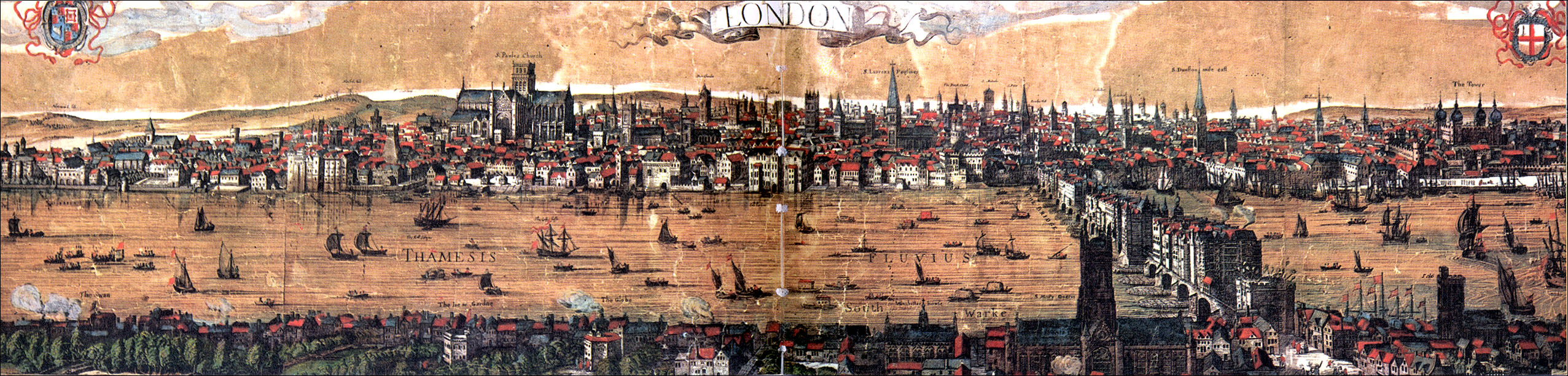
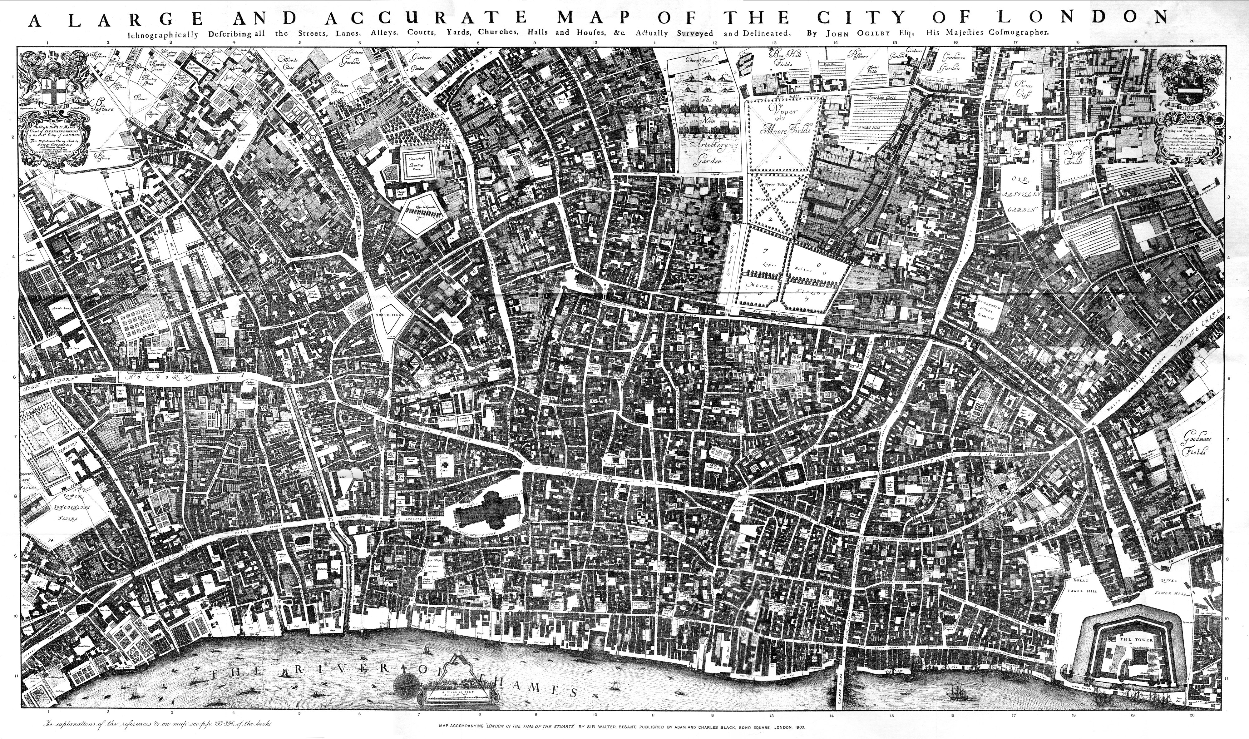